The Townlands of Clontuskert
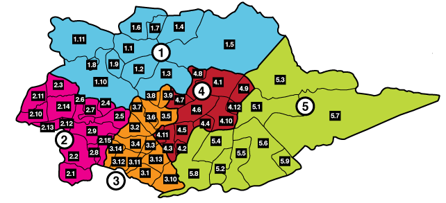
The map below shows Clontuskert divided into its sixty-four townlands. Townlands are the smallest divisions of land in each county and their names are overwhelmingly of Irish origin. The townlands are divided into five colour-coded groups, each with a circled number. Clicking on one of the five groups will bring you to that group on the townlands list below. You can then scroll to the townland that interests you. Click on it and you will be taken to a detailed textual description of that townland, its tenants and the properties rented or owned by them.
|
1. The Northern Townlands
1.1 Glenloughaun
1.2 Gortnahorna Clancarty
1.3 Gortnahorna Clanrickarde
1.4 Graigueawoneen
1.5 Kellysgrove
1.6 Mackney Clancarty
1.7 Mackney Kelly
1.8 Shanvoley
1.9 Templepark
1.10 Tristaun
1.11 Urraghry |
2. The South-West Townlands
2.1 Ardranny More
2.2 Ardranny Beg
2.3 Attibrassil
2.4 Ballynew
2.5 Ballagh East
2.6 Ballagh West
2.7 Corrabaun
2.8 Garrylawrence
2.9 Gorteenaveela
2.10 Gortmore
2.11 Kilnahown
2.12 Lisheenavannoge Blake
2.13 Lisheenavannoge Clancarty
2.14 Liskelly
2.15 Loughaunbrean
|
3. The West Central Townlands
3.1 Bogpark
3.2 Carrowkeel
3.3 Carrowmore East
3.4 Carrowmore West
3.5 Crossconnell More
3.6 Crossconnell Beg
3.7 Drum
3.8 Eskerkeel
3.9 Garryduff
3.10 Gortnamona
3.11 Loughturk East
3.12 Loughturk West
3.13 Sheepwalk
3.14 Taylorstown
|
4 The Central Townlands
4.1 Abbeypark
4.2 Atticoffey East
4.3 Atticoffey West
4.4 Barnpark
4.5 Cappagh
4.6 Chapelpark
4.7 Glenaun
4.8 Gorteencahill
4.9 Kill
4.10 Lakefield
4.11 Newtownkelly
4.12 Stream
|
5. The Longford Townlands
5.1 Ballymanagh
5.2 Barnaboy
5.3 Cloonascragh
5.4 Coolbeg
5.5 Crowsnest
5.6 Gannaveen
5.7 Lismanny
5.8 Somerset
5.9 Tirrooaun |
|
Go to Top of Page
Ballymanagh
Ballymanagh is a townland of 450 acres, situated in the
north-eastern part of the parish of Clontuskert.
The name is from
the Irish ‘Baile Manach’ meaning ‘monk’s townland’ or ‘monk’s
land’. Perhaps the monks referred to were the monks in the Old
Abbey adjacent to Ballymanagh.
In the 1838 map, the townland of Ballymanagh, which has
three ringforts, is divided into fields of varying sizes, some quite
large. Whitehall Bridge is shown on the 1892 map as midway on
the western border, adjoining the townland of Stream. The
northern boundary is the Ballinure River crossed by Clontuskert
Bridge, near Whyte’s house. A smithy is marked on the southern
border across from Nee’s garage. In all, on this map, there are six
sets of buildings, including Ballymanagh Lodge. An east-west
footpath crosses the townland towards the southern end and only
two ringforts are marked.
In the Tithe Applotment Books, Thomas Shadwell is recorded
as paying tithes on 272 acres. According to Griffith’s Valuation of
1856, Allan Pollok was the landlord. Those leasing land were Peter
Coolahan, John Coolahan who was leasing the largest amount of
land at 221 acres, Bridget Kelly, James Kelly, Patrick Kelly Snr.,
Hugh Kelly, Patrick Kirwan, Patrick Curley, Michael Kirwan Luke
Kelly, while those who leased houses and gardens were Bridget
Kerrigan, Patrick Kerrigan, Michael Mitchell and Martin Molloy,
who also leased a forge. The only other lessor was Patrick Kelly
who leased a house, offices and four and a half acres of land to
Patrick Kirwan.
By 1867, the Valuation Records show little change in the
tenants. Apart from forty-seven acres leased by Patrick Kelly Snr.
and Luke Kelly to John Coolahan, Allan Pollok was the landlord for
the entire townland. Bryan Madden leased seventeen acres; Ellen
Coolahan replaced Peter Coolahan as the occupier of fifteen acres.
Martin Molloy is not mentioned. In the 1880s, John Pollok replaced
Allan Pollok as the landlord and Myles O’Dwyer took over from
John Coolahan as the major tenant. John Goff leased a house and
garden.
In the early 1900s, the Valuation Records showed that Myles
O’Dwyer was replaced by Patrick Coolahan. John Bell leased a
house, offices and land from the representatives of John Pollok. In
1915, Richard Howard became the occupier of fifty-seven acres.
Charles Coen took over from Mary Kelly as tenant of land and a
house in 1921. In 1925, James Madden replaced Michael Kelly.
William Alfred Howard followed on from Richard Howard as
occupier of fifty-seven acres. Mary Coolahan leased land, while
Mary Coen replaced Charles Coen. Thomas Lyons became the
owner of twenty-five acres.
The Land Commission was beginning to acquire land in the
early 1930s. Richard and Mansie Howard were given land in
Ballymanagh and in the neighbouring townland of Cloonascragh.
Local farmers objected and demanded land of their own. The
Howard estate was divided and a number of farmers were allocated
divisions of land, including Patrick Colohan, Jamesie Madden, Jim
Curley, Pat Curley, Bernie Kelly and Tom Lyons. New names
appeared over the years that followed; Annie Silver, Michael Ryan,
Peter Kelly, Ignatius Dolan, Eugene Nee, Patrick J. Campbell, Mary
Agnes Cahill, John Burnell and Peter Poland.
Ballymanagh Lodge was built circa 1860. The first resident
was John Coolahan, probably the John Coolahan who leased 221
acres at the time from Allan Pollok. The second resident was John
Bell. He appeared in the 1901 census. John Bell was Scottish and
was married, with two daughters. The next resident at the lodge
was Dan Flattery, an R.I.C. officer who was stationed in
Ballinasloe. He was married with three children Charles, Joe and
Margaret. Tragically, Margaret who was a psychiatric nurse in
Ballinasloe, was struck and killed by a car at Kellysgrove while
cycling home from work on the 24th November 1935. Margaret
was married to Michael Broderick and they had two children Kitty
and Mikey. Mikey remained in the homestead and married Nora
Kelly also from Ballymanagh.
Ballymanagh Lodge had been a great
house for card playing in the Broderick era and people came from
a wide area to take part.
The Colohan family has lived in Ballymanagh since 1835.
Peter built his house at that time and he married and had five
children; Jim, Tom, Catherine Ellen and John. Tom emigrated to
the United States and never returned to Ireland. Jim travelled to
Kansas where he purchased a ranch, married and had thirteen
children. By a stroke of good fortune, oil was discovered on his
land. The remaining brother John stayed on the homestead. He
married Bridget Carthy and had four children. After her death, John
married Nora Dayton and they had seven children.
In the Census of 1901, there were fifteen households with
sixty-five people in the townland. The family names were Curley,
Kelly, Lyons, Colohan, Kirwan and Bell. In the 1911, Census there
was one household less but the family names remained the same. Go to Top of Page
Barnaboy
Barnaboy, ‘An Bearna Buí’, ‘the yellow gap’, is a townland
of about 170 acres.
There is evidence of early habitation, with two
surviving ring forts and the ruins of a few houses and famine ridges,
which possibly date from the 14th century. One ringfort, which
bears the name ‘Lisawadda’, has two enclosures.
By 1770, the Eyre family owned the land and the tenant was
Mrs. Peter Larkin. Charles Seymour, in his will of 1776 gave it to his
son Thomas. Before the Famine, there were at least eight small
farms in the townland ranging in size from five to thirty-three
acres. The tenants were, Pat Hory, Pat Hanny, Barney Larkin,
Thomas Devory, Gregory Colahan, Joe Whelan, Pat Colahan and
Joseph Downey. However, a few years after the Famine, there was
only one tenant left, James Curley, who was paying £95 rent for the
whole 170 acres. Thomas S. Eyre was still the owner but it is likely
that Allan Pollok had leased it from 1855. He purchased it outright
in 1870 and farmed it until the Irish Land Commission purchased it
from his heir, Allan Bingham Pollok in 1924.
The Land Commission changed the layout of Barnaboy in
1926 when they divided the townland into seven divisions of
varying sizes.
Three soldiers were given land as payment for their
services in World War 1. Ambrose J. Forde got thirty-seven acres
and a house. This property changed hands frequently over the next
few years. Michael Hanney, Owen Kelly and Michael Colohan
owned it for short periods before Joe Flattery bought it in 1965. In
1977, his niece Kitty Broderick sold it to Tommy Brennan.
Michael A. Begley got a house and thirty-four acres but sold
it to James Keane. Pat Brennan from Craughwell later became the
owner. Pat was tragically killed in 1946. In 1961, Joe Flattery
bought the farm. After his death, it was inherited by his niece Kitty
Broderick. Ambrose Scott got a house and thirty-two acres but by
1930, he had sold it to John Kelly who swopped it with his brother
Michael (Sonny), from Taylorstown. Other divisions of land were
given to Richard E.Weily, who later passed it on to his son, Eugene.
The Kilgannon family bought Thomas Poland’s land, and a portion
of John Colohan’s. John Hanny bought the remainder. The
McLoughlin family bought Richard Callanan’s land, which was
previously owned by Joe Fallon.
Barnaboy was typical of many townlands. Before the
Famine, it supported at least eight families. Then it became a
portion of the Pollok estate, only to return in the 1900s to the
ownership of seven local families. Go to Top of Page
Cloonascragh
Cloonascragh, in Irish ‘Cluain Eascrach’, means ‘the
meadow of the sand ridge’, referring to the eskers created by glacial
action during the last Ice Age, about 10,000 years ago. Nestling
between two rivers, the Ballinure and the Suck, and bisected by the
Grand Canal, it is over 1,020 acres in area. Its most notable features
are the rolling sand hills from which it has derived its name.
A
roadway between Coreen ford and Ballinasloe is said to have run
across these hills at one time.
The population of Cloonascragh has suffered a dramatic
decline since the early 1800s, when there were at least eighty
houses among the hills. The names of many of its inhabitants have
survived since that time.
The Tithe Applotment Books of 1823
mention five landowners in the area; Thomas Larkin with 101
acres, Darby Colohan with 85 acres, James Madden with 23 acres,
Jo Potts with118 acres and the Grand Canal Company, owning five
acres.
Griffith’s Valuation of 1856 contains an expanded list of
names. The arrival of Allan Pollok saw a considerable shift in land
ownership and occupancy. Thomas Eyre was the major lessor,
leasing 637 acres to Allan Pollok. Allan Pollok himself leased parcels
of land to the following: John Reilly, Richard Colohan, Michael
McDermott, Edmund Colohan, Daniel Poland, William Colohan,
Jeremiah Colohan, Edmund Colohan, Thomas Colohan, Daniel
Furey, John Colohan, Patrick Smiley, Thomas Reilly, John
Madden, Hugh McDermott, Peter Wall, Thomas Colohan,
Edmund Larkin, David Larkin, Patrick Kirwan, Peter Colohan,
Brigid Larkin, Patrick Colohan, John Mulrey, Michael Roche,
Michael Farrell, Mary McDermott, Mary Reilly, the Grand Canal
Company (154 acres), Edmund Colohan, William T. Potts (154
acres), Martin Shine and John Colohan.
There was little change eleven years later in 1867. John
Colohan, Patrick Smiley, John Madden and Thomas Colohan are
not mentioned as tenants. There was one new tenant, Michael
Madden.
However, the 1880s witnessed enormous changes in
population, possibly due to an increase in emigration and Pollok’s
wholesale clearance of holdings. In 1882, John Pollok had become
the owner of the Eyre lands. Many of the displaced tenants found it
difficult to accept their new role as farm labourers on the Pollok
estate. Thomas Reilly, Peter Wall, Edmund Larkin, David Larkin,
Patrick Kirwan, Peter Colohan, Brigid Larkin, Patrick Colohan,
John Mulroy, Mary Halligan, Peter Reilly, Martin Shine, John
Colohan and Mary McDermott were affected by these changes in
their status.
Further changes occurred in 1888. John Poland took over
Daniel Poland’s holding, Jeremiah Colohan’s property became
vacant, Patrick Colohan occupied Edmund Colohan’s holding.
Patrick Colohan took over the holdings of Daniel Furey, Daniel
Poland and Michael Madden. Myles O’Dwyer became the tenant of
108 acres. The 1901 census of the area mentions Patrick Colohan,
William Carry, John Poland, Daniel Poland, Edward Colohan and
Kate McDermott.
John Bell took over Myles O’Dwyer’s holding. By 1915,
Richard Howard had assumed occupancy of John Bell’s farm. The
Carrys, Ryans, McDermotts, Colohans, Polands, Potts and the
Grand Canal Company were now the only occupiers. In 1938,
William Alfred Howard replaced William Howard. In 1959, the
Land Commission owned the Potts holding. Names such as
William Rooney, Patrick Gilligan, John Rigney, Patrick Dolan, and
Richard McGuinness now made an appearance.
Finally, Bord na
Móna took over a considerable area, and the O’Rourkes, Greenes,
Kennys, Lyons, and Cunninghams now feature as owners.
The Whytes are the only residents in Cloonascragh today.
Fursey Whyte’s father came to the area in 1947 and farmed a
substantial holding. Fursey acquired his first lorry on the 23rd of
August 1949 and began to excavate and sell sand from the hills. The
lorry was a two-ton Commer, which he and two employees filled,
using shovels. Over the years, Fursey and his family developed the
business, moving mountains of sand and gravel, both in their
Cloonascragh pits and in other areas as well. Go to Top of Page
Coolbeg
The name ‘Coolbeg’ is from the Irish, ‘Cúl Bheag’ meaning
‘small hill’ or ‘Cúil Bheag meaning ‘small corner’. The townland
contains approximately 215 acres and is rich in archaeological
treasures. There are at least three forts in Coolbeg. One of them,
Caltragh Fort, is on Bleahen’s land. This was the reputed burial
ground for the deceased of Crowsnest and Barnaboy. There are
two barrows, or pre-Christian burial sites, on Jennings’ land, as well
as a large number of ‘lazy beds’, dating from Famine times or
possibly earlier.
The earliest landowner recorded in Coolbeg was in the
sixteen hundreds, Walter Fitz Thomas Kelly. The tithe payers listed
in 1823 were Thomas McLoughlin, Pat Turley, Jo Martin and Co.,
J. Hanney, William Colohan and Charles Seymour. Other tenants
in addition to the Widow Horan were James, Michael and Patrick
McLoughlin.
Griffith’s Valuation of 1856 reveals that Thomas Eyre leased
146 acres, together with a house and a caretaker’s house, to
William Seymour. William in turn leased land and a house to John
and Thomas Colohan. Apart from James Curley of Bog Park, who
leased a few acres from William Seymour in 1865, there was no
change of tenantry until 1870 when the Seymours became the
owners of the townland. The representatives of William Seymour
then leased land to Bernard McLoughlin, James Curley, Michael
Brennan of Bellview, and Patrick Coen of Abbeygormican. Hugh
Bleahen replaced Michael Brennan in 1884. John and Thomas
Colohan continued as tenants.
In 1901, Charles Seymour took over all the lands in
Coolbeg, with the exception of the McLoughlin and Colohan lands.
When the Land Commission acquired the lands around 1937, they
were leased to James Quinn, Bridget Hanney, Martin McKeigue,
John Hanney, Peter Mullery, and Patrick Quinn. Six houses were
built here at a cost of £200 each. John Colohan’s house and land
went to Thomas Colohan in 1895, to John Hanney in 1934, and to
Hugh Bleahen in 1935. Thomas Colohan’s house and land first
went to Sarah Colohan, later to Pat Colohan - the Secretary of the
U.I.L. for many years - then to John Colohan and later to Stephen
Hanney in 1967. John Colohan was the local rate collector and was
one of the first people to own a car in the area. He had two
brothers, Paddy and Michael, and a sister Delia. This family was
known as the ‘Old Colohans’ or ‘Sally Colohans’.
Pat McLoughlin built Coolbeg House prior to 1820. The
land had been leased previously by Solomon Blundell from
Eyrecourt. Coolbeg House became the property of the Seymours
and was eventually given to Bernard McLoughlin who was head
gardener at Somerset House. Bernard was the present owner’s
grandfather but was not related to the original owners of the
property. The road into Coolbeg continued further as far as the
Colohan property.
This road was used as a Mass path to
Clontuskert church for the people of Gannaveen, Crowsnest and
Barnaboy. It passed close to Caltragh Fort, then through Somerset
and on to the church and school. There was also a road or pathway
from Barnaboy through Johnny Hanney’s land, which passed at the
back of Padden Hanney’s house. The path is still visible, as are the
outlines of a number of houses and farmyards. This was also part of
the market route to Banagher.
The number of houses and people in Coolbeg declined
from eleven houses and sixty-one people in the 1840s, to three
houses and twenty people in 1890. The 1901 census shows that only
the three families of Thomas Colohan, Sarah Colohan and Bernard
McLoughlin lived there and by 1911, Thomas Colohan had been
replaced by Maria Colohan. Go to Top of Page
Crowsnest
Crowsnest or ‘Áit tí Phréacháin’ in Irish, got its name from
the Crowe family, from Belmont in Co. Offaly, who had rented the
land from the Eyre family. A much older name for Crowsnest was
Cullydarry and this name appeared on maps until 1850. There is
evidence of early settlement in the townland at Lisnaconicaire fort
which has now been planted with a circle of beech trees. Some of
the names engraved on them date to 1800. There are the remains
of a prehistoric fishpond in the townland. A road linking
Clontuskert Abbey to Ochill monastery once passed through the
area.
In pre-Famine times, nine people are recorded as paying tithes
on their farms; Michael Madden, James Horan, Pat Harney,
Charles Boyle, James Reacy, Pat McLoughlin, Pat Nevin, Bryan
Connelly and William Brother. In 1841, there were fifty-one houses
in Crowsnest, with a population of 266.
A few years later, Allan Pollok became the owner of the 464
acres in Crowsnest and removed all of these tenants. Records show
that there were thirteen houses, some with sheds, rented out to
tenants. Presumably, they all worked on Pollok’s farms.
The
tenants listed were Thomas Skehill, Edmund Connors, William
Carroll, Darby Colohan, Patrick Colohan, Thomas Connolly,
Thomas Bohan, John Corcoran, Pat Corcoran, William Browder,
Bridget Boyle, Mary Hardiman and Patrick Downey. By 1882, John
Pollok had become the owner and only five labourer’s cottages
remained. The population had dropped to ninety from the 266
recorded twenty years previously and the number of houses had
dropped from ninety to twenty-three. This was probably due to a
combination of famine, emigration and Pollok’s policy of taking
over the land. John Keating had replaced Thomas Skehill, Patrick
Goode had replaced Thomas Connolly and Edmund Connors,
while William Carroll and Patrick Colohan remained. Mary
Keating, who replaced John Keating, was not mentioned in the
1896 records.
Alan Pollok brought many changes to Crowsnest. He
developed his farm buildings and removed most of the field
boundaries, thus creating very large fields. By 1896, the townland
had decreased in size by the 145 acres which were transferred to the
neighbouring townland of Gannaveen.
Bigger changes were on the
way however, when the Land Commission took over. In 1924, the
County Council built three houses for Martin Dooley, Michael
Colohan and John Geraghty. Martin Dooley’s house was occupied
by William Kelly in 1948, by Thomas Bennett in 1979 and by
Kathleen Blunkett in 1982. John Colohan was succeeded by
Josephine Colohan and later by William Hoare. John Geraghty’s
house went to James Doorhy in 1948 and later to Margaret Doorhy.
In 1926, eight World War 1 soldiers were given divisions of
land. One of them, Joe Fallon from Poolboy, Ballinasloe, became
second-in-command to Patrick Beegan in the Ballinasloe Battalion
of the I.R.A. During the Civil War, he fought with the pro-Treaty
side. He went on to become an officer in the newly-formed Irish
army and also spent some time training the new Garda force. In
1931, Richard Callanan bought the property. His daughter Mary
married Michael Kilgannon from Caltra.
The last seventy or eighty years have brought great changes
to Crowsnest with land changing hands on a regular basis.
Cornelius O’Sullivan owned Thomas Pardy’s house and land
before Mary Pardy took over in 1968. Tony Pardy lives there now.
Michael Starr got a house and twenty acres which became the
property of Carmel Curley in 1961. Charlie Carry’s house and land
went to Bill Carry in 1965. Patrick Carry, brother of Charlie, sold
his property in 1922 and emigrated to America. He was succeeded
by Michael Hoare. In 1944 William Frehill owned it and later
P.J.Frehill. Richard Weily from Mackney was succeeded as owner
by his son Eugene. Thomas Poland’s land reverted to the Land
Commission and the house in which Josie Farrell lived for some
time, was in ruins by 1971. The land went to the Kilgannons.
Patrick Cahalan, whose brother Francis was killed in World War 1,
sold his farm to Tom Colohan in the 1950s.
In addition to the soldiers’ farms, Patrick Horan, Ambrose
Scott and Thomas Silke also acquired land from the Land
Commission. Patrick Horan’s farm was subsequently owned by
John Colohan and later by Patrick Dolan, before the Land
Commission took it over again and gave it to Patrick Silke.
Ambrose Scott’s portion was transferred to John Kelly and later to
Michael Kelly in 1952. Patrick Silke later became the owner of
Thomas Silke’s land and a small portion of it went to the
Kilgannons. Other divisions of land went to Michael Loughnane
and later Stephen Quinn. Catherine Horan got a house and small
garden which was later owned by James Goode. Patrick Reilly had
a house and farm. Thomas Brennan later became the owner. John
Silke, and later Matty Silke, had a farm and a plantation.
Crowsnest has experienced many moments of sadness
throughout its long history. Sadness again visited the townland in
the year 2002, when Oliver Brennan, the son of Thomas and Ellen
Brennan, was tragically drowned in Australia at the age of twentysix.
Oliver was known for his love of writing and might well have
been one of the team which produced this book. A short poem of
his sums up the relationships which bind townlands and parishes
together.
The Thread Between Us
We are but joined by a thread.
Each time we are together we add another weave.
But time erodes our seam.
And whether we finish a rope or just another broken stitch
I will always treasure the golden thread we spun.
Go to Top of Page
Gannaveen
Gannaveen, from the Irish, ‘Gainneamhín’ meaning ‘the
sandy place’, has seen many changes over the years. In olden times,
there were at least four ringforts there. Before the Famine, 176
people lived in thirty-four houses. The occupants of those houses
were tenants of John Beatty West M.P.
They were, Joe Mullery,
Michael McEvoy, Thomas Kelly, Matt Keane, Joe Guinan, Joe
Staunton, Matt Dolan and Pat McLoughlin. At that time, the area
of the townland was 407 acres, laid out in small fields, which was
common at the time.
Big changes were afoot however. By the time the Famine
had ended, the population had almost halved, falling to eighty three
people. Further change came with the arrival of Allan Pollok.
The townland area increased to 665 acres around 1900 when parts
of the neighbouring townlands of Crowsnest and Tirrooaun were
added to Gannaveen. Field boundaries were cleared when 150
small enclosures were converted into a dozen large fields. The
tenants who lost their land became labourers on the Pollok estate.
Matt Keane seems to have been the only person who kept his house
after the arrival of Pollok. Michael Hanaghan, John Foley, John
Healy, John Ganyon, Thomas Madden, Michael Hoolahan,
Michael Gilligan and Michael Murray, all had houses at this time.
There were a number of ‘double’ houses also, such as Pat Nealon’s
and Michael Gilligan’s, Patrick Bern’s and Martin Cahalan’s, as well
as those of William Leville and Mick Bridle. In addition to these
houses, there were also twelve other labourer’s houses. Over the
following years, the number of inhabitants fluctuated. Patrick
Madden and Michael Houlahan lived there for a while. Henry
Mariner had a forge where John Ganyan lived. This was reputed to
have been a feeding station during the famine.
The labourers’ cottages at Newtown were allocated to new
and existing families, a number of whom also got land holdings. Pat
Burke got the steward’s house and buildings. His son Paddy still
farms there. John Glynn owns some of the cottages in Newtown,
which are now used for tourist accommodation. Patrick Madden,
Annie Silver, Margaret Culleton, Michael Walsh, Joe Cunningham
and Martin Colohan lived in those houses previously.
James Cahalan had a house which went to his son Bernard
but this house burned down in the 1980s. Thomas Hoare had a
shop in one half of the house now owned by Bob Curley. Martin
and Dan Colohan lived in the other section, followed later by
Patrick Beegan and John Burnell. The two houses were combined
into one dwelling by John Curley.
The land originally owned by
Thomas Kenny and later by Annie Silver, was given to Martin
Hopkins by the Land Commission in the 1950s. His son Frank
continued to farm there until his death.
The Forestry Division of the Department of Lands, now
Coillte, took over a total of eighty acres, comprising the Pond
Wood, the Long Wood, Bett’s Wood and Hopkin’s Wood. The
Pond Wood was once a holding pond for the mill at Gannaveen
farmyard. Go to Top of Page
Lismanny
Lismanny, in Irish, ‘Lios Manaigh’ or ‘the monks’ fort’, is
the easternmost townland in the parish. The river Suck forms its
natural border with County Roscommon. From olden times, the
ford at Coreen as well as allowing boat access to the Shannon, gave
the region a strategic importance and a number of roadways
radiated from this river-crossing. An archaeological excavation of
Coreen ford unearthed a late Bronze Age sword, a Viking axe-head,
an early Christian plough share, a Medieval halberd, a Napoleonic
bayonet, two 1760 coins and two Medieval knives.
However, the
construction of the Grand Canal across these routes in 1828 and the
proliferation of road transport in the nineteenth century shifted the
focus away from Coreen and back towards the centre of the parish.
The political decline of the O’Kellys, chiefs of Hymany, enabled
John Beatty West, an MP and barrister from Dublin, and his wife
Elizabeth, to acquire title to much of Lismanny. The Wests were
linked to the Eyres, who had been granted large estates in return
for their part in the Cromwellian military campaign in Galway.
Allan Pollok bought the West estate in 1853 when it became
bankrupt after the Famine. His industrial approach to farming
completely altered the landscape and architecture of the town land.
In the Tithe Applotment Books of 1823-1838, the following names are
listed as tithe-payers to the Established Church: J Persse Grome,
The Grand Canal Co., Hugh Hanrahan, Richard Barrett, Widow
Barrett, Martin Lacy, Michael Hanrahan, Darby Gorman, Michael
Gorman, Thomas McTighe, Patrick Coulahan, Owen Cuolahan
and James Cuolahan.
The names of other people who lived in the
townland between 1827 and 1850 include, Barretts, Brennans,
Coolohans, Corcorans, Curleys, Crosspennys, Donnellys, Fureys,
Gavins, Gormans, Hanrahans, Henaghans, Larkins, Mullins,
Murphys and Traceys.
Names that feature between 1851 and 1900 include Bohane,
Burke, Carney, Cahalin, Connors, Costello, Dayton, Flattery, Fair,
Gaynon, Gilligan, Hynes, Kearney, Kelleher, Kenny, Lyons,
McDermott, McDonald, McLellan, Mahern, Mariner, Madden,
Nixon, Nevin, O’Hara, Poland, Pollok, Scully, Silke, Smyth, Tully
and Walshe.
Evictions around that time led to the relocation of many
families to the callows and along the canal banks. These families
eked out a living by growing vegetables to sustain them and to
generate an income by selling their produce at the markets in
Ballinasloe. Many families managed to survive on fish from the
rivers and game from the expanses of callow and bog.
Travel to and from Ballinasloe was along the canal towpath
and while the canal remained in use, it continued as a busy
thoroughfare. When water levels were controlled on the Shannon,
flooding became an ever-increasing problem, which combined
with the remoteness of the lower Lismanny area caused by the
closure of the canal, eventually led to all of the families moving
from the area east of the townland. The Land Commission began
the process of redistributing the land of the Pollok estate in the
1920s and 1930s. Most of the new landowners in Lismanny had
formerly worked on the estate.
One of the few remaining areas of virgin bog in the country
is currently being developed for public viewing in the Derry area
between Lismanny and Kylemore. Forests have flourished at the
Derry through the centuries. The ‘Gentleman’s Plantation’ and
‘O’Gorman’s wood, named after a forester, owe their existence to
the influence of the landlord who planted trees to support the
rearing of game. Some of the older people remember that in the
1930s, seven large loads of timber left the wood every day and were
delivered to sawmills in Ballinasloe or were transported to Dublin
by rail. Go to Top of Page
Somerset
This townland of 543 acres got its name from the Seymour
family who resided there for more than 300 years and whose
ancestors originated in Somerset, in the south of England. The
imposed name, ‘Somerset’, replaced most of the older place names,
such as Shraogues, Lenefan and Park Roe.
The lands of Somerset,
Coolbeg, Barnaboy and Crowsnest were known as Derry before
the arrival of the Seymours. It is an area rich in history. Some of the
more notable heritage sites include an ancient castle called
Lisheennora, at the back of Hanrahan’s house; six ringforts - two of
them named on the maps as ‘Strong Fort’ and ‘Lisheenclough’; two
ancient burial sites or barrows and a fulacht fia. This is also the
townland where an assortment of Bronze Age objects, known as
the ‘The Somerset Hoard’ was found.
In the 1700s, all the lands in Somerset and Coolbeg had
been granted to the Eyre family of Eyrecourt. Prior to 1746, these
lands were leased by Baldwin Crowe, from Belmont, County
Offaly, and a land agent for John Eyre. Charles Seymour
subsequently took over the lease.
Tenants in Somerset in the 1830s were John Martin, Patrick
Colohan, Patrick Finley, John and B. Goode, Rev. Hannigan,
Bernard Colohan, John Hanney (a wood ranger on the estate),
Captain Warburton, Patrick Larkin, Patrick Goode, Lackey Kelly,
Patrick Blake of Gortnamona, Bryan Kelly and Pat McLoughlin of
Coolbeg.
Burton Persse of Moyode Castle, Athenry, had three lots
of land there at one time.
At the time of Griffith’s Valuation in 1856, William
Seymour leased 451 acres from T.S.Eyre and he was the lessor of
the remaining acres to Patrick Goode, Rev. Adolphus Drought,
Patrick Larkin, John and Matthew Geraghty. They also leased
houses, while John Goode leased a house and garden, Elizabeth
Larkin leased a house only, and Eleanor Kelly leased thirty perches
of land. The tenantry mostly remained the same up to 1875, the
only exception being that James Curley leased 138 acres of William
Seymour’s 451 acres in 1865. After the death of William Seymour
in 1875, large acreages were leased by John Geoghegan and later by
David Craig of Ochilmore Stores, Patrick Cowen of
Abbeygormican and by Michael O’Brien of Dunlo Hill, Ballinasloe.
Tenants who leased smaller acreages were the Rector of the day,
Margaret Larkin, John and Matthew Geraghty, and James Curley.
Prior to 1901, other people who rented land were John Delahunt,
M.D., Thomas Craddock, Thomas Byrne, Hugh Bleahen, and
Thomas Dooley.
In1901, Charles Seymour was again residing in
Somerset. He took back the greater portion of his land, letting it on
the eleven-month system. Those leasing smaller holdings remained
on, namely the Rev. Hugh Oliver, Patrick Larkin, Thomas Dooley,
Thomas and Matthew Geraghty.
In 1937-38 the Land Commission purchased all the land in
Somerset with the exception of 200 acres retained by Charles
Seymour. The present road through Somerset was built at this
time. The ownership changes were as follows: The Glebe house
and lands were leased by R.A.Cooke in 1938; then by John Joe
Burns and later by his brother Pat. The McDonagh family now own
this land. Patrick Larkin’s house and land went to Molly Larkin,
later to Bill McCoy and it is now owned by the Wakefield family.
Thomas Dooley’s land went to Martin Dooley in 1952 and then to
the Kennedy family. Thomas Geraghty’s land went to John
Geraghty in 1929 and was later purchased by Martin Mc Keigue.
Matthew Geraghty’s land went to Patrick Geraghty and to Martin
Higgins in 1937.
The remaining 200 acres of the Somerset Estate were
divided among the following: Patrick Cormican of Cormican’s
shop, Crossconnell; Delia Kennedy, Mary Mahon, Michael
Hanney, George Ogle, Patrick McKeigue, Jimmy Callaghan, Dan
Poland, Patrick Kelly, Patrick Darcy, Patrick Butler, and Martin
Dooley. John Geraghty and Martin Higgins were given additional
land. The Cormican land - where the fulacht fia is situated - is now
owned by Johnny Kelly. Mary Mahon’s land was purchased by
Michael Hanney and the Butler land went to Nora Fallon.
In 1947, Charles Seymour moved to a farm in Trim. The
main portion of Somerset House was demolished, with only the
servants’ quarters left standing. Patrick McDermott took over the
house and part of the land. Pat McManus later purchased this
property. John Kenny of Atticoffey and John Forde became landowners
when the remaining lands were divided. Many of the
existing landowners in Somerset and Coolbeg, acquired additional
land.
In July 1954, Mick Hanney and his son Mikie were weeding
turnips in a field near Caltraghgarraun fort, when they discovered
some unusual metal objects in the soft earth. The Hanneys did not
realise their true value at first. A noted local historian, Martin Joyce
N.T., from Aughrim, took the objects to the National Museum four
years later where they were evaluated by Dr. Joseph Rafferty,
Keeper of Irish Antiquities. He estimated that the find dated from
the middle of the third century B.C. What became known as ‘The
Somerset Hoard’ included such treasures as a gold torc twisted into
a spiral shape with its holding box made of two bronze cylinders,
two bronze open-work mounts, a bronze brooch and a bronze
ingot.
The latest chapter in the story occurred in 1990 when
Eamon Lally N.T., the principal of Clontuskert N.S., discovered
that some further metal pieces, a bronze spoon-like object and a
small bronze plate, had been unearthed in the same field. He
contacted Professor Etienne Rynne of University College, Galway,
who took the objects to the National Museum. The spoon-like
object was discovered to be a prong portion of a La Téne bridlependant
which could date from the 1st or 2nd century A.D., and
therefore might well have belonged to the Somerset Hoard, whose
date had been revised upwards from the initial estimation. The flat
piece of bronze was part of a sheet that encased a wooden
container. Both objects are now part of the Somerset Hoard and are
also housed in the National Museum. Go to Top of Page
Tirrooaun
The townland name, ‘Tír Ruadhain’ translates as ‘Ruadan’s
or Rowan’s territory’. It is the final townland to the right of the
Ballinasloe/Portumna road before the parish of Lawrencetown is
reached. It covers an area of 137 acres. Strangely enough,
Tirrooaun was a much bigger townland prior to 1905 when it
contained 311 acres and included Bet’s Wood, part of Gannaveen,
part of Sycamore Hill where Francis Dolan now lives, part of
Lismanny where David Lyons lives and the adjoining lands
belonging to Joe Kenny.
The older map of 1842 indicated thirteen dwellings in
Tirrooaun. In the later map of 1892, there are just two houses
noted. The landowners here in the 1660s were John Donnellan,
John Lawrence and William McTeige O’Kelly. By the year 1700,
John Eyre was the landlord. It seems likely that the land was leased
to other landlords such as the Seymours of Lawrencetown, the
Gromes of Sycamore Hill and later the Wests of Lismanny. The
tithe payers of 1823 were Michael Caulfield, Pat Larkin, and J.
Farrell & Co.
Allan Pollok owned the entire townland of 311 acres in
1856. He leased houses to Peter Egan, Daniel Fahy, John Robinson,
Alexander Carpenter and Andrew Noone. By 1860, Pollok was
farming 230 acres and leasing the remainder - possibly the
Sycamore Hill and Lismanny sections - to James Ritchey. Peter
Egan was still there, while Morgan Tully and Hugh Loughlin were
the new tenants, living in houses leased to them by James Ritchey.
Mr. Ritchey was probably living in Sycamore Hill House. The two
houses were built by Allan Pollok, and are still to be seen today,
though they are not inhabited. Peter Scully of Cloonascragh was
the last person to live in one of them. A roadway was built in
Tirrooaun by Allan Pollok which passed by John Dolan’s shed, on
by Bet’s wood and out onto the Crowsnest road.
By 1866, Allan Pollok was farming all the land once more.
John Pollok succeeded him in 1874. At that time, there were just
two houses for the workers, Darby Colohan and Morgan Tully. By
1905, those two houses had been transferred to the Sycamore Hill
townland, and the townland area changed to its present 137 acres.
The Rural District Council built a house for John Wills in 1910.
Patrick Wills lived there later and now the Lyons family owns the
house. Andrew Mitchell leased the land up to 1919 from the
representatives of John Pollok, when Sinclair Butson took over. He
resided at Sycamore Hill House and was later killed in a riding
accident. Michael Dolan of Aughrim purchased these lands around
1928; later Ignatius Dolan farmed there, and the lands are still
owned by the Dolan family. The 1901 census shows that the
Colohan and Dodds families were residing in Tirrooaun. William
Dodds was a Scottish shepherd. The 1911 census shows just one
family living there, that of Ellen Kenny.
Go to Top of Page
Go to Top of Page
Abbeypark
Abbeypark is a townland of 283 acres with the ruins of the Abbey situated near its centre. In the 1838 map, there are two very large stretches of land on the eastern side, with smaller fields on the western side. An animal-pound is marked in the southeast of the map, on the spot where the car park for the Abbey is now situated. This pound is not marked on the 1892 map. The mound overlooking the Abbey was the site used for the inauguration of the chieftains of the ruling family, the O’Kellys, who were the patrons of the Abbey.
In the southwest corner of the townland St. Augustine’s Holy Well is to be found. The people of Clontuskert used to visit the Holy Well, particularly during the month of August, and most especially on August 28th the feast of St. Augustine. They said prayers and often left little religious tokens as offerings. On the evening of that day, Mass is celebrated in the Old Abbey for the repose of the souls of all buried there.
In Griffith’s Valuation of 1856, Edward Taylor and Thomas Loftus Jones are the landlords listed. Instead of many small fields, as was the norm in the other townlands, there were two very large stretches of land in Abbeypark, of 151 acres and 110 acres. This may be because the monks farmed that land in the past.
The tenants recorded in Griffith’s Valuation were Pierce Joyce, who leased 151 acres and Charles Molloy who leased 110 acres with a herd’s house. A smaller portion of land, twenty-two acres approximately, was occupied by Thomas Loftus Jones and leased from Edward Taylor. Judith Middleton and Bridget Keane leased two houses and two gardens respectively. At that time, there were just three houses in Abbeypark.
By the mid 1850s, Allan Pollok had arrived on the scene and by degrees began to take control of most of the land. Col. Edward Taylor remained the landlord, while the two houses mentioned previously were now owned by Allan Pollok. John Barrett occupied a large portion of land for a time, but was replaced by Allan Pollok. Very little change of ownership occurs until the early 1900s.
In 1911, Owen Kelly became the occupier of 123 acres leased from Pollok. Owen Kelly remained on the scene until 1945 and was by then the owner of the land, which was later sold to Bernard Naughton.
In 1911, the Rural District Council of Ballinasloe built a house on an acre of land, which they rented to Patrick Burke. It is now unoccupied but when the Burke family, Patrick and his wife, his daughter Julia and sons Bill and Paddy, lived there it was a charming cottage with old fashioned roses all around the door, geraniums everywhere, and many old fashioned varieties of flowers in pots. Musical evenings and dances were sometimes held in the 1920s and 30s. Bill played the flute and melodeon and Julia played the harmonium, while guests danced to the music. Julia Burke was the last to pass away and the cottage passed on to her nephew, Russell, who later sold the cottage.
In the 1930s, approximately seventy acres of the land of Abbeypark was divided by the Land Commission. Those who received divides were James Kelly, Bridget Murphy, Michael and James Coen, John Madden and John Byrnes. In 1942, Peter Keating replaced Bridget Murphy as owner when she died.
Go to Top of Page
Atticoffey West
‘Áit Tí Cobhthaigh Thiar’ is the Irish name of this townland of around 132 acres. It translates into English as ‘The site of Coffey’s house’. According to the 1838 map there are two loughs here called the Attycoffey Loughs, as well as five forts. The fort at the back of Johnny Kelly’s house is called ‘Lisnapastia’ or ‘the Lisnapastia, ‘the children’s fort’
children’s fort’, so called because of the proximity of a children’s burial ground. The fort closest to Sheepwalk is known as ‘Lios a Bhaile’. The 1892 map shows a footpath going through the centre of the townland from Gortnamona to the Old School.
The Tithe Applotment Books of 1823 list the following tithe payers: Joseph Haverty, Barney Madden, Joseph Treacy, Joseph Lynch and Co., Thady Kenny, Joseph Burke, Pat McLoughlin, Widow Treacy, Darby Madden, Bryan Kelly and Co.
Griffith’s Valuation records Patrick Blake of Gortnamona as the owner of the townland, leasing to John Treacy, Patrick Lynch, Ann Gardiner, Bryan Kelly, Austin Madden, Martin Poland and Loughlin Kelly. When Valentine Blake took over in 1860, he leased the remaining lands to further tenants; Patrick Fahy, Michael Kelly, Stephen Burke, Michael Coen, Michael Madden, Martin Monahan, Patrick Kelly, Timothy Kenny, and John Darcy. Although Ann Gardiner is not listed after 1871, she is remembered through an incline on the Old Road, known as ‘Gardiner’s Hill’.
In 1869, Patrick Lynch was replaced by John Cormican, the same Cormicans who had a shop and Post Office later in Crossconnell. In 1882, Patrick Darcy who had married Martin Poland’s daughter, replaced him as tenant. In the same year, John Darcy took over Martin Madden’s house and land. In 1891, Martin Kenny replaced Timothy Kenny. Ten years later, John Kenney replaced John Cormican and Martin Forde replaced Patrick Fahy, John Madden replaced both Stephen Burke and Michael Coen and also took over his father’s holding.
In 1911, the following people became owners of their land. John Murray purchased John Treacy’s land. Michael Kenney, Martin Forde, Mary Kelly, John Madden, John Patrick Kelly, John Kenny, Patrick Darcy, Esther Kelly and John Darcy, all became owners. John Kelly inherited Loughlin Kelly’s land. In 1918, Mary Mahon bought a house and garden on the Old Road from Michael Kenney. By 1928, the house was in ruins. In 1919, Patrick Murray replaced John Murray. In 1924, John Kelly’s thirty acres was divided between Denis Harney, Patrick McKeigue, known as ‘Butson’, and Patrick Darcy. Eventually, this land went to Patrick Kelly, Somerset, John Martin Kenny and John Darcy of Sheepwalk.
John Madden’s land was inherited by his son Patrick in 1949 but in 1951, tragedy struck when the gable-end of his house collapsed on him and killed him. A cattle pen now stands there.
Anne Callaghan replaced Patrick Murray in 1957 and John Martin Kenny took over Michael Kenney’s land. Patrick Kelly’s land was taken over by Patrick Butler in 1966 and later by Nora Fallon in 1969.
The Census of 1901 shows seven households: John Madden, Michael Kelly, Patrick Kelly, Michael Harney, John Treacy, Anthony Carey and James Mahon. A house for the Mahon family is not recorded in the Valuation Sheets until 1918. The Patrick Kelly above was a son of Loughlin Kelly recorded in Griffith’s Valuation. Another son, Malachy, was the father of Bishop Patrick Kelly, Tristaun. Loughlin’s brother, Bryan Kelly, is also recorded in 1856. His family farmed this land until 1966 when it was acquired by the Butlers of Carrowkeel on the death of Bryan’s grandson, Patrick. Bryan’s son Michael, was the grandfather of Michael V. and Johnny Kelly. Their house, built in 1955, was the last house built in this townland. Johnny Kelly is the last remaining resident of Atticoffey West.
The 1911 Census records the households of Mary Kelly, John Kelly, John Madden, Michael Harney, Mary Mahon, John Kelly, Esther Kelly and Patrick Darcy, a total of twenty-nine people.
Go to Top of Page
Atticoffey East
This is a small townland of around 42 acres. The 1838 map shows one fort here.
In 1856, Henry Thompson was the lessor of the townland to Charles Molloy. A herd’s house was included. Maria Molloy took over in 1868 and she passed it on to her son Joseph P. Molloy in 1903. The land was purchased from the Land Commission in 1908. Bridget Molloy took over in 1921. Ann Curley, mother of Patsy Curley of Kiltormer, bought this land in 1949. The herd’s house had by now become a ruin. This appears to have been the only house in Atticoffey East for at least 150 years, which is evident from the 1838 and the 1892 map. Yet the Census of 1841 shows seven dwellings in the townland. The Census of 1901 shows three families living here. Yet the next Census of 1911 has these same families living in Atticoffey West with no one living in Atticoffey East. A recording error has evidently occurred.
Go to Top of Page
Barnpark
The townland of Barnpark covers an area of just over seventy acres, divided into fifteen fields. It once covered an area of seventy-nine acres but sometime prior to 1892, it lost nine acres to Lakefield. The number of fields in this townland had declined from fifteen in 1838 to six by 1892.
‘Barnpark’ is an interesting place name since it refers to a structure so remarkable that a townland was named after it. Given its proximity to the Abbey, it could be possible that the barn in question was a monastic building used for storage. In 1838, there were two houses in Barnpark. One was situated close to the Lakefield boundary, about three hundred metres in from the Old Road, beside a small ringfort. No trace of this building now remains. This could have been the barn from which the townland derives its name. The other house was on the site where the Bleahen family now resides. To the rear of the Bleahen residence, there is a second ringfort, marked on the map as ‘Rabbit Burrow’. Barnpark shares a third ringfort with Somerset, ‘Caltraghgarraun’, which means ‘the burial ground in the grove’.
In 1854, Edward Taylor owned the land of Barnpark and leased it, together with a herd’s house, to John P. Watson who lived at Stowlin, Eyrecourt. In 1901, the land was rented to the representatives of John Watson and later to Kate J. Watson. John Hubert Bleahen became the owner in 1908.
Go to Top of Page
Cappagh
Cappagh or in Irish ‘An Cheapach’, means an enclosed plot of land, usually for the purpose of tillage. In the early 1800s, it was a townland of 101 acres, divided into four fields. There is no indication of a dwelling in the townland on the 1838 map. By 1892 however, the number of fields had increased to fourteen and there were two inhabited houses, one at the corner of the townland near where the Old Road turns towards the church, and the other about five hundred metres from the road in the middle of the townland. A footpath ran in front of this building, coming from the heart of Attycoffey East to the rear, and joined the modern road to Somerset near its junction with the Old Road. At present, the two houses mentioned above are in a state of ruin.
In 1856, two absentee landlords shared Cappagh between them. Colonel J. Edward Taylor leased twenty-three acres to Solomon Watson and in 1863 to John P. Watson. From 1888, the property was leased to the representatives of John P. Watson until John Hubert Bleahen took over the property in 1908.
The other landlord, Henry Thompson, leased two parcels of land. The first of these, a fifty-acre divide, was in the central portion of Cappagh and was leased to Thomas Colohan in 1854. In the 1860s, it was leased to Charles Molloy and remained with the Molloy family until it was sold to Anne Curley in 1949.
In 1854, Thomson leased a second parcel of Cappagh property to Patrick Colohan. The area of this section was twenty- eight acres. His wife Anne took on the lease in 1884 until Owen Colohan became the owner in 1908. In 1928, James Derrick, a native of County Mayo, bought it. James looked after the horses for Jimmy Elder of Kellysgrove House until his return to his native county in 1959. Tim Curley of Chapel Park then bought the farm.
Go to Top of Page
Chapelpark
The townland of Chapelpark derives its name from a small thatched church, which was situated in the vicinity of the Old School in the late 18th century. The area of the townland is 245 acres of predominantly good land, with some rough pasture.
The 1838 map records four houses and five ringforts. These ringforts are evidence of early settlers in Chapelpark. There is a turlough where Cappagh borders Chapelpark. The 1892 map also shows five ringforts and the old Clontuskert National School is also shown on this map.
There was a popular ‘Mass path’ running through Chapelpark which was used by Mass goers from Gannaveen, Lismanny, and Ballymanagh in the past. They would emerge on the Old Road, having crossed the fields from their homes, and enter the little road called ‘Lyons’s boreen’. They were then in Chapelpark. They would cross the fields going westwards and cross the ‘Roddy’ stile emerging at Martin Colohan’s gate, a short distance from the church. Another footpath comes from the Old School going south and coming out on the Old Road at a marked stile. There is a third footpath from the church running north-eastwards through Chapelpark. Altogether, in
Chapelpark there were five stiles, which were carefully maintained in the past. Now, only one remains as it was, the stile between the Quinn and Hannon houses. From the evidence of the 1838 and the 1892 maps, the fields in 1892 were larger.
On the land now owned by Fintan Hopkins there is the ruin of an old house where Patrick Colohan and his family once lived. The house of John Poland was close to the house occupied now by Debbie Callanan, but no trace of it remains today.
The Lyons family lived where Pat and Mary Burns now live. In the 1911 census, there were twelve people in that house and James Lyons was the head of the household. There were triplets in the family, one of whom, Jack, was small in stature and was quite a lively character and a good musician. Most of the family moved away but Mick, Jack and Ciss lived in the family home in Chapelpark. There was a dipping pond near their house where sheep were dipped by the neighbouring farmers. Ciss was very kindly and baked beautiful griddle cake.
Martin Colohan lived with his mother, across the road from the Old School. She was always kind to the schoolchildren who were very fond of her. Martin had a great knowledge of the history of the area and was a great storyteller. He loved to share his stories with others.
What was known as ‘Clontuskert Cross’ is situated on top of a little shrine-like mound on the edge of the road almost directly across from the home of Brian and Dolores Naughton. This simple cross stood in the centre of the parish and was the place where animals were brought after a bargain was struck. Buyer and seller placed their hands on the cross to indicate that the animal sold was ‘genuine’. Little now remains of this cross, which is believed to date from the mediaeval period.
According to Griffith’s Valuation, the landlords in Chapelpark were Pierce Joyce and Thomas Loftus Jones. Those leasing land were James Turley, Judith Coen, John Turley, William Coen, Patrick Colohan, James Lyons, Michael Bohan, Charles Molloy, Thomas Holohan and George Hegarty.
The biggest change in land ownership occurred with the arrival of Allan Pollok who was now the lessor of most of the land in Chapelpark, in place of Pierce Joyce. The names of people leasing land at this juncture were Patrick Goode and John Colohan. Col. Edward Taylor appears briefly as the owner of some land in 1863 but by 1868 he is not mentioned any more. With the passage of time, names changed. In the Valuation Records of the last decades of the 1800s, the following people leased land: John Barrett, Allan Trench M.D., Patrick Lyons, John Poland, Martin Colohan and Michael Coen. Thomas Byrne was a lessor but the main landlord was still Allan Pollok, later to be replaced by his son John. Between 1905 and 1911, the names of Timothy Curley, Bridget Curley and Owen Kelly appear in Valuation Records as leasing land.
The Census of 1901 records four households and nineteen people there. Heads of households were Timothy Curley, John Colohan, Patrick Colohan and James Lyons. In the 1911 Census, five households are recorded with thirty people living in them. Heads of households were Bridget Curley, James Lyons, Martin Colohan, Patrick Mahon and John Poland.
By the early 1930s, Pollok had departed. People now owned their own land. In the following decades new names appeared as landowners; Naughtons, Hopkins, Burns, and Callaghys. Patrick Darcy became the occupier of Michael Mahon’s cottage. There are field names that date back to earlier owners, such as ‘Turley’s field’, now owned by Tony Curley, which still bears the name of the Turleys who occupied this land in the past.
Go to Top of Page
Glenaun
The townland of Glenaun or ‘Gleann Abhainn’ meaning ‘the river glen’, consists of 104 acres. As far back as the early eighteen hundreds, this townland was the property of Burton Persse, who resided at Moyode Castle, Athenry. In the 1850s, the herd’s house and lands in Glenaun were leased to John Eyre. In 1863, John Eyre leased the land first to John Curley of Bogpark, then to James Curley in 1868, and then to Patrick Curley in 1872 but in 1882 John Eyre occupied it again for a further four years. Burton Persse’s son became the lessor of the townland. In 1886, he Bridle Path, Glenaun leased it to James Craughwell of Urraghry. In 1906, Lord Ardilaun, a great grandson of Arthur Guinness, purchased the land. Joseph Walker occupied the land for a year in 1919 and in 1920 it was purchased and divided between Patrick Madden and Roderick O’Beirne. Roderick, or Roddy as he was called, had a shop in Ballinasloe. He employed men to fence his portion of the land using the best of timber stakes, some of which remain today. The bank and ditch between Glenaun and Chapel Park is called Roddy O’Beirne’s ditch to this day. Roddy O’Beirne’s land was bought by John Kelly in 1940 while Patrick Madden’s went to Mary Brock. Patrick or Pat Madden was rarely seen without his bowler hat, even when working in the fields. He built the fences for the Ballinure races which lay adjacent to his land. A bridle path for the exercising of horses is still to be seen near Tom Madden’s house in Glenaun. There was one house in Glenaun and according to the British Census of 1841 seven people lived there. There was just the one house in this townland right through the 19th century. In the Census of 1901 Catherine Madden is recorded as living there and there were three in the household. The 1911 Census records two houses, Catherine Madden’s with five in the household and Anthony Carey’s with two residents.
Go to Top of Page
Gorteencahill
Gorteencahill, or in Irish ‘Goirtín Cahill’ which means ‘Cathal’s or Cahill’s tilled field’, is a townland of eighty-nine acres which was part of the estate of John Beatty West M.P. A large area of the townland bordering the Ballinure River, was liable to flooding and was virtually uninhabitable. However, there were six houses on the higher land where the townland crosses the Portumna - Ballinasloe road. Around the time of the Famine, Colonel Edward Taylor was leasing the whole townland and he sublet it to Thomas Loftus Jones. Jones kept thirty-six acres for his own use and sublet the remainder. John Barrett got a house and forty-three acres; Mary Byrne, née Hynes had four acres on which there were three houses. She let one to Margaret McCooge and the other to Catherine Farrell. Mary Byrne née Dermody, had a house and four acres. One house was vacant.
Over subsequent years, Thomas Jones sublet most of the land to John Barrett who at one stage held seventy-five acres in the townland, including the three houses previously held by Mary Byrne who no longer lived there. Her house was occupied by Michael Qualter and later by Susan McGuinness. Margaret McGooge’s house was vacant for a while but was later occupied by James Keogh. Catherine Farrell’s house remained empty. The other, previously vacant house, was now occupied by Mary Leonard. In 1863, two of the above houses were in ruins.
Shortly after this, the townland became part of the Pollok estate when Allan Pollok took over sixty-two acres and left John Barrett with only a house and eighteen acres. Thomas Jones held on to fourteen acres and Mary Byrne held her house and four acres. Susan McGuinness had left by 1868.
By 1882, things had changed again. John Pollok was in charge and John Barrett got back his holding. John Byrne succeeded Mary Byrne and by 1885, Leonard’s house was no more. Further changes in the early 1900s saw Timothy Curley take over from Thomas Jones and in 1911, Owen Kelly took over from John Barrett. Around this time, the Council built a house which was initially occupied by Malachy Byrnes but he seems to have swopped with John Byrne after a few years.
When the Land Commission took over in the 1930s, the Byrne family acquired much of Owen Kelly’s land. The remainder was divided between John Madden, who now lived in the house built by the Council, and James Coen. The only other change occurred in 1951 when Patrick Gilchrist took over from John Madden. William Byrnes’ mother ran a shop there for many years.
Go to Top of Page
Kill
The townland of Kill is just over 121 acres. According to the
Tithe Applotment Books of 1823, all of Kill was in the possession of a Mrs. Lynch. At the time of the Griffith Valuation in the early 1850s, the land was then owned by Edward Taylor. There were two tenants on the property; James Turley who had a house and garden and Pierce Joyce who rented one hundred and twenty acres.
Pierce Joyce (1809-1883) lived in a beautiful house in Mervue on the outskirts of Galway, overlooking the bay. Tara China now owns the house. Joyce had inherited great wealth from his father, Walter, who was a wealthy banker and merchant. He had a keen interest in agriculture and farmed considerable tracts of land in Galway, Mayo and Clare. He was one of the founder members of the Galway Blazers. His reputation as a landlord indicates that he was at all times just, generous and considerate.
In 1860, Kill was leased to Allan Pollok by Edward Taylor; to John Pollok in 1882 and to the representatives of John Pollok in 1895. James Turley continued to hold his house and garden from the Polloks until 1913. In that year, the representatives of John Pollok leased seventy-one acres to Michael Colohan and forty-one acres to Patrick Colohan. Bridget Colohan took over the lease from Michael Colohan in 1930 and at the same time, Mary Colohan took over from Patrick Colohan. John (Jack) Goode became the owner of Bridget Colohan’s farm in 1942 and when Jack died in 1964, Peter Naughton bought the farm. Mary Colohan’s farm became the property of her nephew Michael Clyne in 1965. Nine years later, it was bought by Michael V. Kelly from the Old Road.
In 1912, the Ballinasloe Rural District Council built three cottages along part of the Kill road frontage. The first tenants were James Kelly, Patrick Colohan and John Birmingham. Frank Turner replaced Patrick Colohan in 1946 and two years later, Vincent Furey became the owner. John Bermingham, the occupant of the third house, lived there for three years until William Burke took up residence. James Lyons followed him as occupier in 1918 and he was in turn replaced by Michael Mariner in 1946.
On the 1838 map of Kill, a foot-stick over Ballinure River was marked. This gave access to people crossing the river between Cloonascragh and Kill where they reached the main road. The foot- stick was used up to the 1960s by local farmers and turf-savers on their way to Kellysgrove Bog. The foot stick was always referred to locally as ‘the plank’, which was all it was - a narrow plank of wood with a sagging wire hand-rail. There was also an eel-weir beside the foot stick where eels were trapped, to provide a food source for local people or to be sold in the markets as an additional source of income.
As has been pointed out in the chapter on Clontuskert Priory, there has always been controversy as to the location of the monastic site which pre-dated the Priory. Jack Goode’s house in the middle of Kill townland was always mentioned in the locality as the site of a monastery which pre-dated the neighbouring Augustinian Priory. Stories circulated of ghostly figures in monk’s clothing who wandered around the locality at night. Was this the site of St. Baetán’s foundation and is this why the townland was known as ‘Kill’ - from the Irish, ‘Cill’ meaning ‘church’? After all, this place is only a few hundred metres from the Priory building.
Go to Top of Page
Lakefield
Lakefield is a townland of one hundred and ninety-eight acres. There is no mention of Lakefield in the Tithe Applotment Books. It appears to have been subsumed into a larger townland called ‘Clontuskert’, which comprised the townlands of Kill and Abbeypark on one side of the Ballinasloe/Lawrencetown road, and Stream, Lakefield and Barnpark on the other. There was a total of over 700 acres in this ‘townland’ of Clontuskert. The land- occupiers were: Mrs. Lynch who farmed 430 acres, and it seems, lived near Shannonbridge on the other side of the Suck; Patrick Molloy with 116 acres; Carter and Kelly 73 acres; James Byrne 53 acres; Murphy & Co. 30 acres and Pat McLoughlin 25 acres. It appears that Mrs. Lynch’s farm occupied all of the present townlands of Abbeypark and Kill.
The next record of property owners, Griffith’s Valuation of 1856, shows a major change in the names of those who farmed in Lakefield. The landlords listed are, Henry Thompson, Pierce Joyce and Edward Taylor. Henry Thompson was an absentee landlord whose tenants were Judith Coen, John Turley and Charles Molloy. Judith Coen rented a house on an acre of land which Michael Coen inherited from Judith in the 1880s, followed by his wife Ellen and later their son Jimmy, the well-known horseman.
John Turley had a house and almost three acres. The subsequent owners of the property were John Barrett from 1867, Owen Kelly from 1908 and Bernard Naughton from 1952. Dr. ‘Midie’ Farrell rented the house for a number of years before the Naughtons took up residence.
Charles Molloy, leased ninety-five acres as well as a house and out-offices. Charles sub-let dwelling houses situated on his land, to John Lynch and John Butler. Nothing is known of John Butler. John Lynch operated a small foundry close to where Ellen Martin’s house now stands. Potato-sized nuggets of the smelted iron-ore from his foundry are occasionally unearthed during tillage operations in a field still known as ‘Lynch’s Field’.
Pierce Joyce leased a house and over five acres to John Turley. Edward Taylor leased a herd’s house and eighty-seven acres of land, part of which is in Lakefield, to Solomon Watson. His herd’s house was located where the Bleahen family now lives.
The County Council built two houses in the early 1900s, on the lower section of the Old Road. The first was for Bryan Quinn. Ellen Martin now lives there. The other was for John Kelly. This was successively inhabited by James Spain, Joseph Farrell, Thomas Murphy and latterly by Frank Finnerty. Near his house, in the ‘Castle Field’ owned by Mark Bleahen, are the foundations of what was reputedly an O’Connor castle. Nothing further is known as to the origins or the owners of this structure.
The 1901 Census shows the households of Michael O’Dea, Michael Coen and Joseph P. Molloy. The 1911 Census records the households of Michael Coen, Joseph P. Molloy, Bryan Quinn and John Kelly.
In a parish which has a total of one hundred and four ringforts, it is unusual that there are none in Lakefield, Abbeypark, Stream or Kill, which may suggest that these were the townlands which were farmed by the monks. Nobody knows for certain why Lakefield is so named. There is no evidence as to where a lake might have been located, nor is there any indication of a lake on any of the older maps. An old footpath, or ‘Mass path’, is marked on the 1892 map. This path originated behind Bob Curley’s house in Ballymanagh and crossed through Lakefield beside its boundary with Barnpark leading to the Old School. There was a shop on this path just across the ditch beside the ringfort in Barnpark, which served the needs of parishioners using the pathway.
Go to Top of Page
Newtownkelly
Newtownkelly, a townland of fifty-one acres. The junction at the main Kiltormer-Ballinasloe and Ballagh road is known locally as Madden’s cross. In the heart of the townland is a small lough. The 1838 map records six houses and there was a reduction to four in1892. In recent years, the names Kenny and Madden are most commonly associated with Newtownkelly but 150 years ago, two others families lived in the townland, namely the families of Patrick Lynch and Patrick Battel. At the time of Griffith’s Valuation, Patrick Battel occupied a house and garden there. Frances Sharpe acquired this house, but by 1926, the house had fallen into disrepair. The property was later sold to John Martin Kenny’s father for £10.
Patrick Lynch lived on six acres and also farmed in Atticoffey. He was a blacksmith and operated a forge there. When the Maddens were building the dipping pond many years later, they found the remains of an anvil during the digging. The Atticoffey Kellys farmed a few acres in Newtownkelly. The Kennys leased most of the remaining land from Patrick Blake of Gortnamona. John Kenny had a shop here and was the local family grocer. In 1901, the only inhabitants of Newtownkelly were John Kenny and his household of eight. Nora Madden’s niece Rita, married John Martin Kenny and they raised a family there before their place was sold. The 1911 Census notes Bridget Kenny as head of the household, with six in the house.
Go to Top of Page
Stream
Stream is a small townland of forty-seven acres. A stream flows along its southern boundary with Ballymanagh and gives the townland its name. The land rises in a gentle slope away from the road. On the 1838 map, Stream was divided into twenty fields of varying sizes. Over fifty years later, the number of fields remained unchanged. There is no record of who owned these fields prior to the Griffith Valuation of the 1850s, when the townland was divided between six people. The absentee landlord was Henry W. Thompson.
The sixteen acres farmed by Thomas Barrett, stretched right along the stream from the Lakefield boundary at the upper end, down to the main road at Whitehall Bridge where his house and out-offices were situated. His son Patrick took over from him in 1882 and he was succeeded by John Barrett later that year. Ellen Barrett his successor, took over in 1901. The house was in ruins by 1937. Thomas Bannerton became the owner of the property in 1947, followed by James Hession two years later and then by Peter Keating in 1953.
The adjoining property, along the road in the Ballinasloe direction, was occupied by John Datten who had a house on an acre of land in the 1850s. The spelling of the occupants of this property varies considerably in the Valuation Records. John Dalton is given as the householder in the 1880s while J. Deacon is recorded as the owner in 1908. Ellen Deacon’s name is written as such in the 1932 records, even though she was always known in the locality as Ellen Deaton where she was the very popular proprietor of a shop at the Gate Lodge in Lismanny, where she then lived. Her nephew Paul Brennan inherited her land in 1959. Peter Keating bought it seven years later.
The next holding along the road is comprised of two fields, joined at their corners, giving the property a figure-of-eight shape. The house on five acres of land was occupied in 1856 by Patrick Cunniffe and then by the representatives of Anne Cunniffe in 1882. Malachy Byrnes, in 1897, was the next to come into possession. In 1908, the house was described as derelict. John Byrne took over the property in 1916, although he was living in Gurteencahill by this time. His son William became the owner in 1972 and farms the property until the present day.
Mary Flattery lived in her house on an acre of land in the 1850s. A Mary Flaherty is described as the tenant twenty years later. They may be one and the same person, despite the difference in spelling. The name Mary Flaherty is back on the Valuation Records in 1908, followed by John Flaherty who in turn was replaced by Michael Kelly as owner in 1916. His son, Jim then took over. He was known as ‘Big Jim’ in the locality and was known over a wide area as having a cure for ringworm. His wife Mary outlived him and she in turn was replaced as owner by her son Peter, or ‘Bobby’, as he was known. In the early years of the 1900s, the family moved to a new Council house across the road in Kill. In the 1850s, John Murphy was the tenant in the adjoining property, which comprised a house and sixteen acres of land. Catherine Murphy took over the property in 1884 and was succeeded by Bridget Murphy in 1931. Peter Keating, a resident of Abbeypark, became the owner in 1942.
The final house in Stream, bordering Lakefield, stood about a hundred metres in from the road and was built on seven acres of land. The first occupier mentioned in the records was Honoria Staunton. She was a widow with a large family and her son John took her place in 1882. He remained as tenant until Michael Coen bought the holding in the early 1900s. Ellen, his wife, inherited the property and in 1926, her son, also Michael, became the owner. After his death in 1977, his wife Helena, who taught in Clontuskert National School for many years, took over the property.
The 1901 Census records the following households; Catherine Murphy, John Flattery and James Kelly. In the 1911 Census, John Barrett replaces John Flattery. As is the case in some of the neighbouring townlands, there are no ringforts or archaeological monuments in Stream. Neither are there any houses or inhabitants in the townland. The only relics of human habitation are the outlines of buildings, which once flourished along the short stretch of road frontage which forms the eastern boundary of the townland.
Go to Top of Page
Glenloughaun
Glenloughaun, from the Irish ‘Gleann Lochán’, ‘the lake glen’, is a townland of almost 300 acres. A branch of the Esker Riada forms the spine of the townland and in pre-Famine times was dotted on either side with small thatched cabins. According to the British census of 1841, there were sixteen dwellings there with 102 people and this is endorsed in the map of 1838. The 1892 map indicates a drop in the number of houses to ten.
The Tithe Applotment Books show that there were fifteen tithe payers in 1823.The people named were James Brown, Thomas, William and Frank Elliot, James Reddy, James Todd, James Rorke and another James Rorke who was a policeman along with seven Stenson families.
By 1856, Lord Clancarty was the owner of the townland and he let the lands and thirteen houses to his tenants. According to Griffith’s Valuation, the tenants were Robert Sinclair, William Sale, John Rorke, Thomas McNamara, James Johnston, Gilbert Johnston, James Walshe Jnr., Elizabeth Johnston, Ann Sale, Mary Brown, Andrew Stenson, James Walshe, and James Naughton. The changes in the occupiers of lands after that were as follows: William Sale’s house and land were taken over by George Cooke in 1873 and John Rorke’s by Edward Hall in the same year. Thomas McNamara had three portions of land in the townland. Two of these went to Richard Sheppard in 1879 while James Johnston took over the third. Elizabeth Johnston’s house and land went to James Quilty in the 1860s and remained in that family name. One portion of land farmed by James Walshe was taken over by Hugh Armstrong in 1882. Mary Browne’s land went to Isaac Walshe in 1882 also. Philip Stack had a house and garden from around 1860. He was a schoolteacher in Glan. The other family names on Griffith’s list were still there until the new division of land took place. In 1910, all the land in the townland had been taken over by the Land Commission and was divided among the following: Jonathan Ogle, George Cooke, Edward Hall, Richard Sheppard, Hugh Armstrong, Fanny Quilty, Richard Sale, William Stenson, Arthur Walshe, Patrick Naughton, Isaac Walshe and Rachel Galbraith. Of these, only the Ogle and Sheppard family names remain in the townland.
George Cooke’s land went to Charles Wakefield in 1923 and later to Isaac Walshe. Edward Hall’s land went to Richard Sheppard in 1918 and later to Eddie Sheppard. Hugh Armstrong’s was divided in 1932 between John McCoy, Patrick Murray and James Walshe. The farms of John McCoy and the Walshes are now owned by the Sharpe family. Fanny Quilty’s property went to Patrick Murray in 1924. Richard Sale’s (the name changes to Seale around 1919) went to Elizabeth Bonney in 1933, to James Ogle and to J. Donelan. William Stenson’s went to John Loughnane in 1918, to Michael Callaghan in 1938, to Frank Tuohy in 1945 and later to Isaac Walshe. Patrick Naughton’s passed to Elizabeth Bonney in 1931, and later to William Walshe. Rachel Galbraith’s went to Michael Callaghan in 1938, to Frank Tuohy in 1945 and then to Isaac Walshe.
A story is told of the aforementioned William Stenson who had a pet rat during his lifetime. On the evening of William Stenson’s burial, his pet is reputed to have made a hole in the grave and was buried with his owner.
The 1901 Census records ten families living in Glenloughaun; Ogles, Cookes, Halls, Sheppards, Quiltys, Seales, Stensons, Walshes, Naughtons and Burkes. The 1911 Census is the same with one exception; the Burke family is no longer there. Other names from the Church registers and not mentioned already are Keating, Kelly, Flanagan, Maguire, Cummins, Grady, Ryan, Bamberry, Booth, Madden, Flannery, Kennedy, Dooley, Brophy, Buckley and Duff.
Go to Top of Page
Gortnahorna
Gortnahorna, in Irish ‘Gort an Charna’, ‘the field of the cairn’, suggesting a prehistoric presence in the area, is a townland of 690 acres. The townland maps of 1838 and 1892 show the townland divided into Gortnahorna Clancarty (240 acres) and Gortnahorna Clanrickarde (450 acres). Eight ringforts are also marked and four of them are named; Lislea (Clancarty); Liserbin, Lisnavin and Lissahoreed (Clanrickarde). The 1838 map shows three houses in Gortnahorna Clancarty, including Gortnahorna House. These houses are substantially larger than the three indicated in the Clanrickarde division. Close to the three houses in Gortnahorna Clanrickarde, a pound is marked. The 1892 map shows twelve dwellings on the Clanrickarde side and the same three on the Clancarty side.
The Tithe Applotment Books of 1823 record two tithe payers in Gortnahorna, Bernard Browne (365 acres) and Joe Duffy & Co. (136 acres). Griffith’s Valuation of 1856 gives more information about the owners, their tenants and the size of the holdings. Lord Clancarty is recorded as leasing his 240 acres to Isaac Walshe, James Cooke and William Sharpe. These lands were taken over by the Land Commission in 1914 and were subsequently purchased by the same families who have farmed there into recent times.
The Clanrickarde side of the townland is recorded in Griffith’s Valuation as having three lessors: the Marquis of Clanrickarde (150 acres), Andrew Browne (40 acres) and Edward Browne (253 acres). The Marquis appears to have leased the land in earlier times to the Brownes and they in turn are recorded as lessors for a number of years. In 1856, Andrew Browne leased his 40 acres to Michael McGuinness, James Dermody, John McGuinness and Daniel McGuinness. This is the Lt. Col. Andrew Browne who also owned land in Templepark. The Marquis rented 145 acres and herd’s houses to Edward Browne in 1856. William Hushen (Hession), and John Hushen are recorded as leasing three acres and one acre respectively from Clanrickarde.
Edward Browne leased a separate holding of 121 acres to Michael McDermott and 132 acres to James Smith. By the 1860s, Andrew Browne had become the lessor of all Gortnahorna Clanrickarde and is recorded as renting it to Michael McGuinness, James Dermody, John McGuinness, Daniel McGuinness, William Hushen, John Parker, Edward Browne (145 acres), William Sharpe (121 acres), and Edward Lennon (132 acres),.
In 1863, Honoria McGuinness succeeded Michael McGuinness, William Sharpe’s holding passed to Joseph Kelly and Edward Lennon’s to Pierce Joyce in 1864. In 1867, Pierce Joyce was replaced by Samuel Sharpe and he in turn was replaced by William Ivers in 1870.
In 1882, Edward Browne’s holding was taken over by Hubert Bleheen. Andrew Browne, the lessor, and Gerald Hanlon took over the land previously leased by Joseph Kelly and William Ivers, respectively. In 1884, the Marquis is again mentioned as the lessor of some of the Gortnahorna Clanrickarde lands and, by 1903, he had replaced Andrew Browne as lessor of all these lands. The tenants’ family names remain the same for the most part, with the exception of Francis Joyce who replaced Gerald Hanlon in 1884, Catherine Hession who replaced Daniel McGuinness and James Cooke who took over William Iver’s holding in 1898.
In 1909, Mary Naughton, a teacher in Clontuskert N.S., leased James Dermody’s holding. In that year also, Patrick Callaghan acquired Catherine Hession’s out-offices and land and in 1915, Michael Callaghan acquired the rest of her land. In 1910, Michael Scott acquired a house on one acre cut from Hubert Bleheen’s holding and leased to him by the Ballinasloe Rural District Council. This page in the Valuation Records shows that W.C. Ryder, secretary of the Race Committee leased the Stand from John Ryder for £2. The entry also records that the stand was pulled down in 1916. John Ryder’s 121 acres, previously held by Francis Joyce, was taken over by James Cooke in 1914.
By 1920, Clanrickarde’s land had passed to the Land Commission, the Galway County Board of Health and the Rural District Council of Ballinasloe. New landowners included Thomas McKeigue, Joseph Tuohy, Michael Tuohy, while houses were acquired by Charles Mitchell and Peter Murray. The Valuation Sheets record that the Grand Canal Company owned one rood and four perches in 1920. John McCoy acquired this plot later. A weir and sluice gate, which were built by the Company, are marked on the 1898 map.
In 1920, Michael Callaghan acquired a house and shop which was bought by Jack Kelly in 1951 and is now the Turley home. In 1920 also, Bridget McGuinness acquired a house and out- offices from which she ran a shop and Post Office. This house was purchased by Michael Stapleton in 1954. In 1947, Mary Naughton’s house and land passed to her niece, Bridget Kenny. In 1956, most of the Bleheen land in Gortnahorna was taken over by the Land Commission and was later divided among a number of farmers in the area.
Michael Ward, a native of Mountbellew, who has lived in Gortnahorna for almost thirty years, is the last remaining tinsmith in the West of Ireland. His workbench is a boat anchor, which his late father, also a tinsmith, obtained from a Donegal fisherman. For many years, Michael supplied the surrounding area with rubbish bins made from old car bodies. His speciality was a coal bucket made from copper water-cylinders. He featured on a national newspaper when he handmade the copper wash basins in ‘An Táin’ pub in Ballinasloe.
The Census of 1901 records the following householders and the numbers in their families, in Gortnahorna Clancarty: Thomas Sharpe (6), James Cooke (4) and James Walshe (7). The same families are recorded in 1911. The following households are recorded in Gortnahorna Clanrickarde in the 1901 census: Thomas McGuinness (4), Catherine Hession (5), John Hession (7) and Catherine Dermody (2). The households recorded in the 1911 Census were Thomas McGuinness (4), Mary Naughton (2), Michael Scott (2), John Hession (7) and Pat Callaghan (8).
Go to Top of Page
Graigueawoneen
The Irish name ‘Gráig an Mhóinín’ translates as the ‘hamlet of the little bog’. The 1838 map shows the acreage to be 311 acres while this increases to 338 acres in the later 1892 map. In the earlier map, more than twenty dwellings are indicated in the townland, while in the later 1892 map, only five are shown. The Rugby Club and the Golf Club are in this townland.
The Kellys of Kellysgrove were the lessors of all the lands here up to 1852 when Lord Clancarty took over the Kelly estate. The Kelly tenants were Edward Mullery, John Rorke, Mrs.Madden, Patrick Madden, John Burke, Martin Mullery, Richard Butler, Michael Mullery, Hugh Kenny, Roger Berrane, David and Thomas McDermott, John Mullery (Snr. and Jnr.), Bernard Coolahan, Dennis Whelan and Dr. Burke, while part of Rossgloss, also in this townland, was leased to Daniel Mc Guinness, Thomas Hanlon, Edward Mullery, and Robert Adamson.
There were big changes following Lord Clancarty’s takeover. He had five tenants while he retained 248 acres for himself. His son Viscount Dunlo leased thirty-five acres, a house, offices and land, while the other four tenants were John Mullery, Edmund Mullery, John Burke and Brian McDermott. The Viscount’s house and lands were taken over by Edward Mullery in the 1860s, later by Patrick Mullery, by James Bohan in 1933, and this later became the property of Paddy Fahy.
John Mullery’s property went to Michael Mullery, later to John Fahy, then to Honoria Fahy and later to Thomas Fahy in 1930. It is now the property of Seamus Fahy. This house, the gable of which is near the road, has the original window frames, which were made by Thomas Burke. Thomas was known as a master carpenter and coffin maker. With his brother John, he made the seats for St. Augustine’s church. They are still in use.
John Burke’s house and garden passed to Thomas Burke in 1901, to Molly Glynn in 1942 and it now belongs to Seamus Fahy.
Bryan Mc Dermott leased a house in 1856 which later passed to John Menihan and then to John Burke. Lord Clancarty later leased 133 acres of the 248 acres of land which he had retained, to a Scottish settler Warner Barr, in 1859. These lands had been drained by Lord Clancarty. A new residence was built in Rossgloss by Mr. Cody of Lawrencetown, Pollok’s chief contractor. In September of 1860, Prince Napoleon, nephew of Napoleon Bonaparte, called to Rossgloss, home of Mr. Barr, on his way back from visiting Mr. Pollok’s farm in Lismanny. He inspected the farm steading, the dairy and a new steam-driven threshing machine.
James Barr took over from Warner Barr in the 1870s. He was a member of the Ballinasloe District Agricultural Society for many years. His involvement in the effort to secure fair rents for the tenants of Clontuskert is dealt with in Chapter 15. In 1889, he stood as the Unionist candidate for the Poor Law Union elections in the electoral division of Kellysgrove, but was defeated by the Nationalist candidate, James Curley. He died in 1907 at the age of sixty-five years and was buried in the graveyard at Glenloughaun. He donated a stained glass window to St. Augustine’s church in memory of Fr. Mulkern P.P. At the same time, he also donated a stained glass window to St. Matthew’s church in Glenloughaun.
Part of Lord Clancarty’s land was leased first to John Nesbitt and later to James Barr in 1901, and in 1909 to Rev. Richard Shannon, Rector of Clontuskert. Dennis Horan owned this land from 1927 and it is now part of the Golf Club. All the lands in Graigueawoneen had been purchased by 1916 under the Land Purchase Act. William Hession took over the remaining Barr lands together with Rossgloss House, in 1909.
The 1901 Census shows that there were four houses in Graigueawoneen with nineteen people living there. The householders were Nora Fahy, Catherine Mullery, Thomas Burke and James Barr. In the 1911, Census three houses and thirteen people were recorded, the householders being Nora Fahy, Patrick Mullery and Thomas Burke.
Go to Top of Page
Kellysgrove
Kellysgrove is a townland of over 1700 acres, situated between two rivers, the Suck and the Ballinure. At one time, the Grand Canal went through the townland. A children’s burial ground, the remains of an old stone-age village or clahan as well as traces of the Slí Mhór can be seen there. The stream which crosses under the road near Goode’s in Moher, is known as the Fair River and marks the boundary between the parishes of Clontuskert and Ballinasloe.
According to the Tithe Applotment Books of 1823, Dennis Kelly was the only tithe payer at that time. The Kelly tenants were Mullery, Flannelly, Hanlon, Kenny, Berrane, McGuinness, Mc Daniel, McClean, Coolahan, Burke, Flynn, Ashe, Egan, Tracey, Rowe, Leonard, McManus, Larkin, Coates, Hynes, Cunningham, McDermott, Flanagan, Reilly, and Dennison. The estate was purchased by Lord Clancarty in 1851 under the Encumbered Estates Act. In the same year he paid the passages to America for a number of people who had been tenants on the Kellysgrove property.
Griffith’s Valuation shows that Lord Clancarty’s largest tenant was Henry Gascoyne of Mackney who leased 200 acres, while Robert St.George leased Kellysgrove House and 120 acres. Other tenants who leased land and a house were John McLane, Thomas McDaniel, John Dennison, Honoria Reilly, Michael Reilly, Patrick Reilly, John Leonard, John Mullery, Thomas Hanlon, John Cunningham, Daniel McGuinness, Thomas McDermott, Michael Mullery, Thomas Cunningham, Michael Burke, Alexander Nicholl and Michael Scott. Tenants who leased land only included Walter McDonagh, Thomas Wakefield, Mary Wakefield, Elwood Nevin, Patrick McDaniel, Patrick Nevin, Kieran Fallon, Denis Tunney, James O’Neill, Thomas McNess, Thomas Mooney, William Smyth, James Lyons, William Burke and William McDaniel.
After the 1860s, some changes of tenancy occurred. Halpin, Rorke, Fallon, Seale, Coffey, Chesnutt, Mullery, McDonnell, Forde, and Armstrong were the new names to appear. In 1862 Robert St. George’s leased land and Kellysgrove House were taken over by John Ronaldson. Henry Gascoyne’s leased land was taken back by the Earl of Clancarty in 1887 and leased to Robert Ronaldson in 1903. John Mc Mullen had been Secretary of the Grand Canal Co., which owned 105 acres along the canal and its supply stream. In 1863, William Digby Cooke became Secretary and remained in the post until 1879.
In 1903, Lady Adeliza Clancarty was the lessor of some lands in Kellysgrove. The names of new tenants at this time were Dennis Keating, William Goode, Daniel Kelly John McDonald and Frank Clarke. From 1905 onwards, the Land Commission, through the Land Purchase Act, gradually purchased the Clancarty lands in Kellysgrove. Julia Keane took Dennis Keating’s land in 1909 while the name Lady Catherine Trench replaced that of Lady Adeliza Clancarty in 1914. In 1916, J.J. Elder took over the Ronaldson lands and Kellysgrove House, Malachy Tully got a house and land and James Horan received land only. New names in the 1930s were Rose Farnon, Thomas Curley, James Dolan, Richard Sheppard, Elizabeth Walshe, Hubert Croffey, John Mc Coy and John McKay. Patrick Parker leased three acres of land in 1938 for one year only.
The children’s burial ground on Donnelly’s farm is called ‘The Grove’ or ‘Lios’. Among the many small stones marking the burial places of infants, there is one large headstone, now broken in two, on which is written the name, Cecelia Louisa Kelly. One story tells that this girl fell in love with an ‘undesirable’ and was locked in her upstairs bedroom from which she fell while trying to escape to meet her lover. Another version says she committed suicide by throwing herself out of the window, while a third tale involves a stepmother who locked her in the cellar and starved her to death. We can only surmise what the true story was. It was unusual to find an inscribed headstone in a children’s burial plot.
A study of the 1838 O.S. map shows many dwellings dotted along the edges of the bog and in the callows of Kellysgrove. In the 1892 O.S. map, some are still marked but many have disappeared. The earlier map indicates seven dwellings on the western bank of the canal and eight on the east. Indeed the British Census of that period shows a total of 49 houses in Kellysgrove. On the lower side of the canal today, there are the remains of two houses. Ned Kelly lived in one and a Reilly family in the other. The Reillys were employed by the Polloks to fish for eels. There was an eel weir on the Suck at that time where eels were caught. They were sent to Dublin by train and shipped to London, where they were served in the top London hotels for breakfast next morning. In the early 1940s, a big drainage and road-making scheme was carried out in Kellysgrove and Pollboy. Nine hundred acres of bog were drained, giving employment to fifty men for two years.
On the west bank of the canal, lived the Curleys, McDonnells and Maguires. Paddy Curley was a canal ranger. Those living in the callows were in a way, self-sufficient. Some caught fish, salted them and preserved them for the winter months. They shot wild duck and geese. Some owned goats and sold their milk in Ballinasloe, as well as fish from the river. They also cut turf, which they sold around the town. It appears that one or two from the area were quite adept at making ‘home brew’. The Kelly family was the last to leave the callows. Ned Kelly was a carpenter and was involved in making seats for the church in Creagh. Each carpenter was expected to make one seat per day but Ned could finish his seat by lunchtime, which left lots of time to pursue other activities.
A man named Hanney lived at one time near the entrance to Kellysgrove House. Mr. Hanney’s job was to keep the canal supply stream in good working order. The Lyons and Cunningham families were long-time residents of Kellysgrove. ‘Cunningham’s Prophecy’ has been talked about down through the years and many are steadfast believers in its accuracy, even to this day. The story goes that a Jack Cunningham around the year 1798, was working in the fields of the local landlord at Kellysgrove. He fell asleep at the headland and when he awoke, there was a book by his side and a man dressed in black was walking away into the distance. No one could decipher the contents of the book except Jack Cunningham himself. He told others about many of the prophecies contained in the book: news would come to the house carried on sticks, a reference to telephone wires; grass would grow in the centre of the roads, a reference to the coming of the motor car. There were many other such prophecies. Some days after the death of Jack Cunningham, the man dressed in black returned to Cunningham’s house, walked into the room, opened a drawer, took away the book and never uttered a word.
Viscount Dunlo, son of Lord Clancarty, owned a hunting lodge in Kellysgrove. It was situated on the narrow road from Seamus Fahy’s old house, before it passed through the Golf Course on its way to Kellysgrove bog. The entrance was dominated by a large gate between two huge pillars. People remember tales of horses and carriages driving to the Lodge where, after drinks, they would follow the hunt, either walking or on horseback. The gentry also had pheasant and grouse-shooting parties on the bog. The Lodge was known as ‘Nancy’s and Judy’s’, after two sisters whose job, in addition to that of caretakers, was to clean and polish the hunting gear of the guests.
On the Ballinasloe side of Whyte’s new Concrete Works lived the Nicholls family. Later, Hugh Armstrong who was a farmer, lived there. His sister, Elizabeth Walshe and her daughter Elsie, lived with him. Miss McCoy managed a branch of the Post Office in the same location in the early1900s. Later, Ernie Walshe and his wife lived in that house. At the T-junction where the road from Kellysgrove meets the main road, a smithy known as Scott’s forge is marked on 1892 O.S. map. At a later stage, Mick Mariner was a smith there. Willie Poland later bought the house and forge. The 1901 census records seventeen houses and ninety people living in Kellysgrove, while the 1911 census shows a slight reduction to fifteen houses with eighty people dwelling in them.
Kellysgrove House once stood where Donnelly’s house now stands. Charles Dennis Kelly, who died in 1852, is recorded as the occupier in 1823. William James Kelly was living there around 1837 and he may have been a son of Charles Dennis. William James died tragically in 1855 while he was attending the races of Knockbarron, Loughrea, when a portion of the stand fell on him. Charles Kelly’s wife Elizabeth (neé O’Donel) lived until 1863 and was buried in Clontuskert Abbey.
Robert St. George occupied the house in the 1850s. John Ronaldson lived there from around 1862. He died in 1890 and is buried in Glenloughaun graveyard. Robert Ronaldson succeeded him. Later, the house and land were put up for auction. However, the estate was not purchased until 1916 when James J. Elder became the owner. He was an auctioneer and shopkeeper in Ballinasloe where Gullane’s Hotel is now. The estate was later taken over by the Bank of Ireland and in 1943, Paul A. Rothwell bought it. Malachy Donnelly purchased it in 1948.
Kellysgrove House was three stories high, and had an extensive view of the surrounding countryside. Downstairs there were three spacious reception rooms. Older people, who knew the house as children, remember that each of the reception rooms was bigger than the average bungalow of today. The stable yard included a large coach house, which is still in use. The house was approached by a long avenue, lined with beech trees. However, the trees were cut down during the war when the price of timber was high. A gate lodge stood at the beginning of the avenue but only a portion of the gate lodge wall now remains.
Go to Top of Page
Mackney
There are three Mackney townlands, Mackney Kelly and Mackney Clancarty in Clontuskert, and Mackney in the parish of Ballinasloe. The Irish name ‘Meacnaigh’, means ‘the place of the wild parsnips.’ In the 1823 Tithe Applotment Books, the following names are recorded as tithe payers in Mackney Kelly and Mackney Clancarty; Edward McDermott, Edward Walshe, James Walshe, John Walshe, James Fahy, Pat Berrane, Thomas Clarke, Joseph Kenny and Joseph Glynn.
Mackney Kelly is a townland of 102 acres. In the first half of the 19th century, W. J. Kelly of Kellysgrove was the owner of sixty acres, while Lord Clancarty owned the remaining forty-two acres. Up to 1851, Joshua Gill leased the Kelly portion of the townland together with a house and in 1856, he leased the property from Lord Clancarty who had recently purchased the Kellysgrove lands. James Coffey leased the house and lands in 1883 followed by Kate Coffey in 1905. It was taken over by Margaret Heagney in 1927, by John McKay in 1934 and by William Goode in 1938.
The remaining forty-two acres of the townland were not let by Lord Clancarty until 1860, when Warner Barr was the lessee. In 1879, James Barr took over from Warner Barr. He farmed the land until his death in 1907. William Hession took over this land in 1910 and he was succeeded by Mary G. Raftery in 1918, and by Thomas Fahy in 1929. All the Clancarty land in this townland had been purchased by the Land Commission by 1916. The O’Neill, Casey and Kelly families came to live there in 1938.
According to the 1838 map, there were eight houses in the townland and by 1892, only one remained. This house was across the main road from Seamus Fahy’s old homestead. The townland which in 1841 had eight houses and thirty-eight inhabitants appears to have been seriously affected by the Famine, because in 1851 only three houses and eight people remained. In 1891, the numbers had decreased to one house and four inhabitants. In 1901, only one person, Julia Carroll, lived there. Ten years later, the house was occupied by Mary Keane with two in her household.
Mackney Clancarty was a townland of 282 acres. Lord Clancarty owned this land in 1856 and the tenants were John Joseph and William Burke who leased land only, while William Fahy, Jane Walshe, John Howie, Mary Walshe, Richard Butler, James Connor, Thomas Clarke, John Glynn, and Margaret Fahy, all leased houses and land.
James Connor’s house and land went to James Comber as did Thomas Clarke’s and John Joseph’s. All the Comber lands mentioned here were taken over by William Kelly and Martin Glynn in 1926. William Kelly was a teacher who taught in Mullagh National School. He married Kate Comber, a daughter of James Comber. He moved to Brackernagh and their land went to John J. Curley in 1928. Martin Glynn’s land passed to James Glynn in 1969. The land leased by William Burke went next to William Corcoran, and was later divided between William Rorke and Patrick Gately. The Gately section was taken over by Thomas Rorke in 1902. In 1938, William Rorke purchased the land. John Canavan took over William Rorke’s original acres in 1919 and this land is still in the Canavan name. William Fahy’s house and land was later leased to James Fahy, then to Margaret Curley. John J. Curley became the owner of the property in 1926. Jane Walshe’s house and land was first taken over by Joseph Walshe, then by Samuel Walshe. Fred Deacon became the next owner in 1933, followed by Wilbert Browne. Wilbert Browne had built a house there, which still stands. John Howie’s house and land went to Arthur Walshe, then to the representatives of Margaret Walshe,
next to Ralph Walshe in 1942.
Mary Walshe’s house and land remained in the Walshe name until it was taken over by Joseph Deacon in 1905. He was succeeded by George Deacon in 1926 and by William Goode in 1947. Michael Mullery took over Richard Butler’s house and land in 1906 and Thomas Sheppard became the owner in 1919. It is still owned by the Sheppards. John Glynn’s house and land went to James Glynn, to Martin Glynn in 1923 and to James Glynn in 1969. Margaret Fahy’s house and land went to Mary Fahy in the 1860s, to Bridget Fahy in 1905, to James Fahy in 1928 and it is now owned by Pat Fahy. The Land Commission had taken over all the Clancarty lands in Mackney by 1910.
Between 1841 and 1851, the population dropped from eighty-nine to seventy-eight people and there was a decrease in the number of houses from sixteen to ten. The 1901 census records a further drop to thirty-four people living in eight houses. The families named were Curley, Comber, Walshe, Mullery, Fahy, Glynn, with the addition of the Deacon family in 1911. A Dean and a Mullin family, mentioned in the church register but not in the census, also lived in the townland.
Go to Top of Page
Shanvoley
This townland of forty-two acres has many variations in its spelling, ‘Shanvalla’ and ‘Shanbally’ being just two. Its Irish name, ‘An tSean Bhuaile’ means ‘the old milking place’.
Griffith’s Valuation shows that Barton Connolly occupied the townland in 1856, with a house and out-offices. The Connollys emigrated to America in 1872. Their son Thomas married Kate Reynolds of Moher, Ballinasloe and the marriage took place in New York. Their son Joseph was a surgeon for forty-six years in Long Island, before his death in 1957. He was a member of the American College of Surgeons and had been appointed by Presidents Woodrow Wilson and Franklin D Roosevelt to head the Draft Exemption Boards in both World Wars.
Lord Clancarty became the owner in 1874 and leased the townland to Isaac Walshe. It passed to his son Thomas and he in turn left it to his nephew Chesney Boden. Walshe is the only name recorded both in the census of 1901 and 1911. The cluster of houses to the left of Shanvoley and also called Shanvoley on the 1838 and 1892 maps, is actually in the townland of Tristaun and this area has become known locally as Shanvilla. This may explain why the British census of 1841 says that there were eight houses in Shanvoley and only six in Tristaun. This seems to have been corrected in the 1851 census when two houses are recorded in Shanvoley and twelve in Tristaun.
Go to Top of Page
Templepark
This townland of 118 acres was notable for its church and graveyard, marked in the O.S. Map of 1838. The graveyard was also used as a children’s burial ground. A footpath ran through the townland just north of the church, to join the road into Cornfield House. Templepark was uninhabited in 1838.
In 1856, the Marquis of Clanricarde was the owner of the townland, leasing the entire acreage to James Craughwell. A herd’s house was recorded at that time. By the 1860s, Lt. Col. Andrew Brown, who lived at Glentane near Mountbellew, was the owner. His first tenant was James Galbraith, then Joseph Kelly and later, James Hession.
The Land Commission divided the land in 1921-1923 among John Hession, Thomas Tuohy, Bridgid Conroy (Loughrey), and Patrick Hession. The Tuohys and Conroys came from the Woodford area and the Hessions came from Cappagh, Kilconnell. John Hession’s son, also John, was born in 1900 and was known by the name ‘Jack in Tomple’, to distinguish him from his cousin ‘Jack at the Lodge’ who lived up the road at Kirwan’s Lodge in Tristaun. Jack was the local ‘vet’ during the lambing season and frequently crossed the fields to help his neighbours in Tristaun.
The Kelly family now own John Hession’s land. A daughter, Mary, owns Tuohy’s. Two other daughters married and settled in Clontuskert. Kathleen married Jackie Clarke from Tristaun and Margaret married Michael Costello from Gorteenaveela. Winifred, another daughter, became a nun in the Augustinian Order, and took the name, Sr. Catherine in 1948. She worked in England until she died in 1995. She is buried in Clontuskert with her three brothers, William, Patrick and Tommy. Patrick Hession’s is now owned by John Hession of Cornfield.
The last remaining resident in Templepark is Teresa Loughrey in whose holding the graveyard is located. The outline of the church foundations can still be seen. Large stones without inscriptions are the only monuments to those buried there. Teresa was told by her late father Patrick, that the last burial in Templepark was an infant from the locality who died shortly after childbirth. During his own lifetime, Patrick Loughrey could regularly be seen sitting on the stones at the graveyard. From his lofty position, he could look across Shanvoley and Attibrassil to his right, straight ahead to Tristaun and Ballagh, and to his left to Cornfield and Gortnahorna. He could even see the church in Crossconnell through the bare branches of the winter trees, while over his shoulder was the church of St. Matthew in Glan.
Go to Top of Page
Tristaun
Tristaun is a townland of 752 acres. The name ‘Trostán’ may have been given to the townland because the contours of the sand hills in the area reminded people of a pilgrim’s staff. The sand from these hills, which stretch from Templepark almost to Liskelly, was used to make and maintain the local roads.
The Kirwan family, who were descended from one of the fourteen Tribes of Galway, farmed the lands in Tristaun at one time. Later, Lord Clancarty bought the lands and he leased them to James Craughwell and James Cooke. The latter farmed 440 acres in that area in the middle of the nineteenth century.
Shanvilla is marked as a village in the 1838 map, and is not to be confused with its neighbouring townland, Shanvoley. Communal farming was still practised there in the latter half of the 1800s. Horans, Morans, Patrick Hannon, Edward Scott and Mary Raftery farmed eight acres in common and in 1875, they farmed a further ten and a half acres as one unit. Other occupiers of land around that time were Patrick Kelly, Laurence Story and William Burke. Simon Sellars occupied the Corn Mill and ninety-four acres. His land was leased at varying times from the 1880s to Joseph Burke, Thomas Byrne, James Bradshaw and Sarah Kelly. In 1906, a portion of the Corn Mill was temporarily occupied as a Police Barracks at a rent of £39 per annum. In 1907, Kate Sellers had leased land to Rev. Richard Shannon of the Glebe in Somerset. Sam Walsh became the owner of the Corn Mill and part of the lands, while John Paul Butler now owns the remainder. One of John Paul’s fields is called ‘fir bán’ and a boundary wall is called ‘Shannon’s Wall’. At one time, there was a hedge school just beyond Butler’s house; some of the stones still remain in position there.
The 1901 Census reveals that twenty-seven people lived in six houses in the area, including eight in Michael Hession’s at the Lodge and five people in John Loughnane’s house. In 1910-1913 the lands were divided and the inhabitants of Shanvilla consolidated their holdings. Edward Scott moved to Upper Tristaun and John Hannon acquired Edward’s land. Others got farms, which varied in size from one to fifty-eight acres, resulting in twenty-seven families occupying land there. New names to appear were Peter Kelly, Joseph Sinclair, Francis Quilty, Michael Murray, John Murray, Michael Campbell, James Woods, Malachy Kelly, John Clarke, Bernard Larkin, Martin Forde, Michael Costello, and Elizabeth Cooke. The Rural District Council built houses for Patrick Hurney, Michael Barry and Thomas Quinn.
Before the 1910-13 distribution of lands, Michael Hession already farmed forty-one acres there, which included land at Kirwan’s Lodge. The Lodge was demolished around 1911 and the stones were used to build walls on the farm. Part of the stabling was converted to a dwelling house.
Hurney’s Forge was built in 1912. Some of the neighbours helped out in its construction and in return got their horses shod free of charge for a time. The Forge was also a sort of ‘Social Centre’. Men passing the road called for a chat and to light their pipes. It was a great place to meet, especially on a wet day. The Bonfire Night Dance was always held there. In later years, Paddy Hurney became well known for making trailers and horse boxes.
Paddy was a dedicated amateur historian and when he retired from the forge, he had a set of four videos professionally produced, which recorded the various farming, and social activities which took place during the year. He then built a replica of an old Forge to hold all his tools and implements, as well as a thatched cottage furnished after the fashion of the time. He received a Special Achievement Award for his endeavours in the Rehab Galway Person of the Year Awards in 2004.
Apart from the Kellys, the descendants of the original inhabitants of Shanvilla have died out and their houses are in ruins. Horan’s and Moran’s property is owned by John Quinn. Hannon’s land was acquired by Michael Frehill. In Upper Tristaun, Woods’ and Campbells’ lands are now owned by Padraic Kelly. Two field names recall their original owners ; ‘Wood’s Paddock’ and ‘Campbell’s Hill’.
Paddy and Sean Quinn, who owned a horse-drawn sprayer with a timber barrel holding the spray, sprayed the potatoes. Jackie Clarke, an accomplished fiddle player, cut hay for the locals when the horse and mower went out of date. John Larkin sowed grass seed with an instrument called a ‘fiddle’, which had a box for holding the seed that was scattered by a mechanism operated in a violin-bow movement.
The travelling community came at regular intervals during the year and they caused a little bit of excitement when they appeared. The inhabitants and the travellers knew each other down the years. There was Johnny Ireland, Johnny Lovely, Georgie, Mrs. Lambe, Molly Lee, Danny Donovan, the Stokes, Lynches and the various families of Wards. Their visits were part and parcel of rural life and while people were a little apprehensive of them at times, nonetheless they were greeted with open arms.
Tristaun was the homeland of a number who dedicated their lives to the service of religion; Pat Joe Kelly who became a bishop, Anthony Kelly who also joined the S.M.A. for the African Missions, Patricia Larkin and a sister of Michael Woods, both of whom became nuns.
Go to Top of Page
Urraghry
The name of the townland has appeared in a variety of spellings - Urrachree, Urghary, Urroghry, Orrahory and Ougharie. The origin of its meaning is difficult to establish. One theory is that it derived from the keening of women over the fallen at Aughrim ‘Ó Mo Chroí’-‘Oh my heart’, while another is ‘Urchair sa chroí’ –‘shot in the heart’, also with Battle of Aughrim connotations. The word may derive from the Irish, ‘Iubhrach’, meaning ‘yew land’.
Urraghry is a townland of 635 acres. Near Melehan Bridge, a small, triangular portion of Urraghry is situated on the other side of the main Galway-Dublin road. The Melehan River forms its border with Aughrim. There was a footbridge over the river between Tristaun and Urraghry and stepping-stones are marked in the townland maps. There are six forts, one of which, Caltragh Fort, is situated in the west of the townland. At the back of this fort is a children’s burial ground.
The townland has three villages marked on the maps- Sinclair’s Village, Wakefield’s Village and Urraghry. Surnames are sometimes associated with fields and hills. ‘Colly’s Hill’ is near John and Sylvia Black’s house. Fifty Urraghry dwellings are marked in the 1838 map while in the 1892 map only fourteen houses are shown.
The tithe payers in 1823 were; two Joseph Wakefields, William Wakefield, Widow Wakefield, James Todd, Cormac Nicholson, George Cooke, Austin Nolan, Edward Farrington, Edward Murphy, Mrs. Longworth, Joseph Craughwell and Dennis St. Clare. In 1856, Lord Clancarty owned all the land in Urraghry. His tenants were Thomas Walshe, Edmund Berrane, Honoria Donnellan, Thomas Walshe (a stone mason), Charles Wakefield, William Wakefield, John Galbraith, Jane Sinclair (Joseph), Jane Sinclair (Charles), Dorothea Craughwell, Richard Cooke, Anne Keating, George Cooke and William Sale. Charles Keane rented a house while James Keane was the lessee of land only.
Changes in ownership recorded in the Land Commission division are as follows: Edmund Berrane’s house and land were taken over by William Raftery; the Donellan land by James Wakefield and later by William Wakefield; James Keane’s land by Bernie Goode; Thomas Walshe’s by Edward Walshe, later by William Wakefield, Jane Sinclair (Charles) by Simon Cunningham, later by William Rorke and then by James Craughwell.
Maria Finn took over William Sale’s house and land and later Richard Moorehouse farmed there. There was one other major change. Stephen Williams acquired 140 acres of the lands of Richard Cooke, and this land in turn was taken over by John Howard who also took over Dennis Keating’s holding. Alfred Howard took over these lands in 1902. The other family names remained up to the 1900s.
When the Land Commission divided the lands in 1909, the following became the occupiers: Ann Wakefield, William Raftery, Alfred Howard, William Wakefield, Charles Wakefield, Thomas Wakefield, Rachel Galbraith, Bernard Goode, Benjamin Sinclair, James Craughwell, Robert Moorhouse, and Richard Cooke. Interestingly most of the names remain the same as those who occupied the land prior to 1909.
Ann Wakefield’s land went to Thomas J. Wakefield in 1913 and to James Walshe in 1965. William Raftery’s went to Alfred Howard in 1910. Alfred Howard now owned three farms in the townland, which were taken over by James Horseman and later by Edward Cook. In 1939, Charles Wakefield took over the larger farm while Charles Wiley took over the other two. Charles Wiley’s lands went to William Coen, in 1954. William Wakefield’s went to Thomas J. Wakefield in 1936, and later to James Walshe.
Charles Wakefield’s original holding went to James Walshe in 1965. Thomas Wakefield’s went to Leslie Wakefield in 1956. Rachel Galbraith’s went to Frank Joseph in 1937 and later to William Joseph. Bernard Goode’s and Benjamin Sinclair’s lands are still in the respective family names. James Craughwell’s went to Thomas Coen in 1914, to Charles Wakefield in 1938 and later to Leslie Wakefield, while Robert Moorhouse’s also went to Leslie Wakefield. Richard Cooke’s went to Martin Condron in 1941.
The 1901 Census records eleven families: three Wakefield families, Howards, Rafterys, Cookes, Moorhouses, Craughwells, Taylors, Sinclairs, and Leonards. The 1911 Census shows nine families, Goldricks, Cookes, Sinclairs, Leonards, Coens and four families of Wakefields. Other names contained in the church registers and not mentioned here are John Honan whose father Patrick was a stonemason, Margaret Connaughton, and Major Edmund L’Estrange of the Bombay Staff Corps. Urrachree House marked in the 1892 map was home to many families -Nicholsons, Cookes, Williams, Howards, Horsemans, Wakefields and Blacks.
Ardranny
The name Ardranny or ‘Ard Raithnighe’, is generally thought to mean ‘the height of the ferns or bracken’. There are two townlands, Ardranny More and Ardranny Beg. Ironically, Ardranny Beg is the larger one containing 302 acres according to the 1838 map, while Ardranny More has 197 acres. In the 1892 map, Ardranny Beg has 283 acres while there are 179 acres in its sister townland. The earlier acreage was lost mainly to Ballyterrim in Cappataggle parish.
There are many ‘mass paths’ to be seen on the maps. Most of the people from Ardranny would have used these paths going to Kiltormer church and school. Others went through Garrylawrence and Loughaunbrean to the Gorteenaveela road and thence to Mass or to school in Clontuskert. Livestock sometimes were brought to the market through Taylorstown and on to the Ballinasloe- Kiltormer road. The present Ardranny road through to Dereen and Kiltormer parish was built in stages and was not completed until around 1946. Men from Ardranny like Jimmy Brennan, and Brendan Lyons worked at the building of this road.
Art Aylward was the landlord of the two townlands in the early 1800s. The only other names mentioned in the Tithe Applotment Books of 1823 were Thomas Scott and Co.
Ardranny Beg has a fort, called Liosnafairy and one of the best-preserved barrows or burial mounds in the parish. Nearby is a pond that floods in winter. In years gone by it provided the younger folk with many happy hours of skating. In Sean Madden’s land, there is a large mound known as Madden’s Fort and this dates back to the Bronze Age.
There were between eight and ten houses in the townland in 1838 and there was little change in that number in 1892. The Right Honourable Richard W. Greene was the landlord of the two Ardranny townlands in 1856 and his representatives continued to lease the lands until 1912. In Ardranny he was known as ‘Baron Greene’. The Right Hon. Greene became Attorney General for Ireland in 1846 and had extensive lands in counties Galway and Roscommon.
The Ardranny Beg lands were leased to the following: John Ryan, Michael Campbell Jnr. and Snr., Mary Scott, Bridget Scott, Thomas, Dennis and Mary Dolan, Patrick and Thomas Costello, William O’Connor, Bryan Flaherty, and Peter Larcom (Larkin?). Except for John Ryan, the Costellos, William O’Connor and Peter Larkin all the tenants leased houses also. Peter Larkin had a forge in Ballyterrin where the horses of the locality were shod.
The Ryans leased large tracts of land in the area. John and later Joseph and James Ryan, who took over one section of Michael Campbell’s land, farmed there up to 1910, as did Michael Ryan. The last person to lease land was Mrs. Alice Ryan. It was said that almost half of the stock at the Ballinasloe fair carried the Ryan brand. The Ryans employed a Burke family as herds and they lived in a house behind the present Dowd house. Later Peter Dowd became herdsman. By 1912, all their land had been taken over and divided by the Land Commission.
Patrick Hobbs, who married Honoria Campbell, took over Michael Campbell’s house and land. His son John, who was a rate collector, took over in 1959 and his niece Ann (Pixie) later owned the property. Mary Scott’s house and land went to her son Thomas in 1882 and to Pat Madden of Carrowkeel in 1903. He had married Mary Ann Scott. Bridget Scott’s house and land first went to Anthony Scott, then to Michael Scott in 1903 and later to Tony Scott. The 1901 and 1911 census records seven families here; Flahertys, Martin and Dennis Dolan, Scotts, Dowds, Maddens, and Hobbs. After the division of the lands by the Land Commission, the owners listed were Patrick Shiel, Patrick Dowd, Patrick Tierney, Patrick Madden, Patrick Hobbs, John Flaherty, Martin Dolan, James Dolan, Patrick Costello, Edward Costello, Bryan Connor, Honor Flaherty, and Matthew Larkin. The Shiel lands are still in the family name as is the Dowd homestead. Thomas Dolan’s house and land went to Dennis Dolan, later to Ellen Dolan and then to John Flaherty in 1909. The O’Connor land was in the O’Connor name until it was bought by Martin Moylan in 1954.
Ardranny Mor. The map of 1838 shows a fort to the west of the townland and fourteen dwelling-houses, and on the 1892 map there are nine. In 1856, John Ryan leased land only. The other tenants of R.W.Green were James Farrell, Peter Larkin, James Nolan, Patrick Poland, Michael Mooney, John Lyons, Martin Lyons, Patrick Duane and Patrick Hanrahan. Apart from the fact that Thomas Brennan got a house and land in 1875 and that Patrick Broderick took over the Hanrahan house and land in 1897, there was little change there until 1914 when the Land Commission divided the land. The 1901 and 1911 Census shows that six families lived there, the Brodericks, Duanes, Polands, Lyons, Brennans and Farrells. These families continued to occupy the land after 1914 with the addition of the Larkin family.
Go to Top of Page
Attibrassil
The townland of Attibrassil or, in Irish, ‘Áit tí Bhreasail’ or ‘the site of Brassil’s House’ has 175 acres and lies in the west of the parish. The 1838 map shows one fort and six or seven dwellings. The list of tithe payers in 1823 were: Joseph Kelly, Joseph Murray, William Kelly, Art Walshe, Michael Dolan, Ann Beggs and Joseph Walshe.
The Earl of Clancarty owned all the land in 1856. His tenants were John Lyons, Timothy Tevlin, Arthur Walshe, James Murray, and James Craughwell. The last reference to John Lyons was a note on the townland Valuation records, in 1862, which states, ‘Lyons gone to Australia’. James Walshe took over his land. It has remained in the Walshe name since, with Sam Walshe taking over in 1916 and Wesley Walshe in 1962. The Tevlins have lived in Attibrassil since the time of Griffith’s Valuation. A field on their land is known as ‘Thady’s Garden’, which is believed to have belonged to Thady Kelly.
When the Land Commission acquired the Clancarty Estate in 1910, William Walshe took over from Art Walshe. This land, now belonging to Nanny Walshe, was taken over once again by the Land Commission in 1974 and divided between Patrick Harney, Patrick Curley, Patrick Larkin, and John Clarke. James Murray’s land went to the Quinns in 1883 and has remained in the Quinn name ever since. James Craughwell’s land went first to Thomas Coen, then to John Jennings in 1928 and is still in the Jennings name.
A family of Nolans lived in the townland, one of whom became a priest, taking the name Fr. Elias. He was educated locally, attended secondary school in Loughrea and joined the Carmelite Order before going to Belgium. He returned to Loughrea in 1880 and helped to organise the collection of funds in the U.S. for the building of the Cathedral in Loughrea. He supported the Young Ireland movement, the Fenians, and the Land League. He wrote an Irish prayer book and many school textbooks. He died in 1904. The 1901 Census shows a John Quinn and his wife Margaret and seven other occupants in the house. They do not appear on the townland valuation sheets and are not listed in the 1911 census. These were the Quinns, who later lived near Caher cross and were said to live in a house across the road from Liskelly gate at one time. The valuation record sheets show Michael McLoughlin as occupying a little over an acre and a house in 1865, which was leased to him by James Craughwell. By 1925, the house was in ruins.
Rose Tevlin was a great card player and no one could make potato cakes like her. Sam Walshe was renowned for treating sick animals, especially horses, and he had a cure for burns. Nanny Walshe had various cures for kidney complaints and skin conditions. Paddy and Sean Quinn did all the potato spraying with a timber horse drawn sprayer. Paddy, an avid GAA follower, regularly travelled to their land in Ballydavy, greeting all the youngsters on the way with the ‘Clare shout’.
Go to Top of Page
Ballagh
Ballagh is made up of two townlands, Ballagh East and Ballagh West. The Irish form, ‘An Bealach’ means ‘the pass’ or ‘the main road’. In the Tithe Applotment Books of the 1820s, there are only two entries, Pat Madden and Co. and Michael Curley and Co. This shows that a small group of landholders got together and paid their tithes under one name.
Ballagh West is a townland of 164 acres. In the 1650s, a daughter of John Lawrence of Lawrencetown called Mabella, married J. Kelly Esq. of Ballagh. His is the earliest name recorded for the townland. The ruin of Ballagh Castle is in this townland and the earlier map of 1838 marks a schoolhouse, of which only traces remain. Some surviving field-names are ‘Castle Park’ and ‘Lacknacrucha’.
Griffith’s Valuation of 1856 shows that the landlord of the entire townland was James E. Maher of Liskelly. His tenants were John Ryan, (Jnr.) who leased the land only, Denis Reynolds and Robert Sharpe, both of whom leased a house and lands. John Ryan’s land was taken over by John Connor in 1865, who also took over Robert Sharpe’s house and land in 1866. Mary Ann Jennings leased all this property in 1887, and in 1888, Patrick Curley was the occupier. Denis Reynolds’s house and land went to Thomas Reynolds in 1897 and in 1910 he took over part of Patrick Curley’s land also. In 1910, the Rural District Council built a house here for John Barry. The 1901 and 1911 Census record two families, Michael Broderick with six in the household and Thomas Reynolds with nine in his household.
The Congested Districts Board took over all the Maher lands in 1917 but it was only in 1922 that the land was divided. The following became the owners: Thomas Reynolds, Michael Broderick, Patrick Cormican, and Patrick Kelly.
Thomas Reynolds’s house and land first went to Bridget Reynolds and then to Michael Reynolds in 1958. Michael Broderick’s land went to Michael Barry and to John Joe Barry in 1954. Patrick Cormican’s land is still in the Cormican name. Patrick Kelly’s house and land went to Thomas Kilduff in 1934. He had married Mary Kelly, daughter of Patrick. Matthew Jennings purchased this property in 1953. Patrick Murphy took over John Barry’s house in 1948.
Ballagh East is a townland of 142 acres. In the map of 1838, it would appear that the houses were all near each other in a little village on the eastern side of the townland. It had four ring forts, three of which, remain. Field names include, ‘Glanaulin’, ‘the beautiful valley, ‘Riask’, ‘the swamp’, ‘Clonaveela’, ‘the mile of meadow’ and ‘Parkglanna’, ‘the clean field’.
According to Griffith’s Valuation of 1856, James McDermott owned the entire townland which was leased to John Curley (Jnr.), John Curley (Snr.), John Curley (Thomas), Thomas Concannon, and Patrick Concannon. These tenant family names remained right up to the 1960s when Brendan Brien took over the Concannon land. He had married Nora Concannon. The John Curley (Jnr.) of the 1850s was Patrick’s or ‘Poppy’s, grandfather. John Curley (Thomas) of the 1850s was the grandfather of P.C. Curley. The John Curley (Snr.) of the 1850s was the grandfather of Josie Curley. The 1901 Census indicates four families with twenty-seven people while the 1911 Census shows the same four families with twenty- five people. At present, there are three Curley families and one Brien family residing there.
P.C. Curley emigrated to Chicago. He later returned and ran a business in Killimor. He was an elected member of Galway Co. Council in 1920 and was re-elected in 1925. Josie Curley had a thresher and threshed not alone for the farmers of this parish but for the surrounding parishes as well. When a pig was ready to be slaughtered, Josie was called upon.
Major McDermott was the owner of lands there in the early 1800s. The McDermotts lived in Ramore in Killimor and owned 3,500 acres in the 1870s. In Clontuskert, James McDermott was the lessor of over 1,000 acres. He died in 1923 aged 87 years and was pre-deceased by his wife Lucy who died in 1915. Both are buried in Clontuskert.
Go to Top of Page
Ballynew
This townland is the smallest one in the parish with an area of a mere twenty-four acres. The 1838 map shows a fort here to the north of the townland. This fort is not marked in the later 1892 map. There were only two houses there from the 1800s.
James McDermott was the landlord in 1856 and Patrick Fallon and James Butler were his tenants. Later, Edward Haverty rented a field there. Then Peter Fallon became the lessor of the original land, and leased land to Thomas Butler who also took over Edward Haverty’s field. Peter Fallon remained the lessor of the greater portion of the land. Patrick Coleman of Loughturk married Catherine Fallon and he became the tenant in the 1880s. Peter Coleman took over in 1936 until that portion of Ballynew was acquired by the Land Commission. It was purchased by Joseph Kelly and it is now the property of Mattie Kelly.
Edward Haverty’s field went to Patrick Butler, then to Mary Hession. James Butler’s land went to his nephew Laurence Butler, to Mary Casey in 1912, and to Nicholas Tobin in the 1930s. The 1901 Census records Patrick Coleman living there with nine in the household and Laurence Butler with two in his household. The 1911 Census records only one family there, Patrick Coleman’s, with seven in the household.
Go to Top of Page
Corrabaun
This townland of ninety-four acres is situated in the west of the parish. The Irish translation ‘An Chóra Bán’ means ‘the white round hill’ but can also mean ‘the white weir’, or ‘white marsh’. The 1838 map shows two or possibly three houses there, while the 1892 map indicates two houses. The Tithe Applotment Books of 1823 contain the names of the following: Michael Craven, Edward Dolan, Pat Nevin, Thomas Shiel and Thomas Reynolds.
Griffith’s Valuation records that Lord Clonbrock of Ahascragh, was the landlord of the townland. He was of the Dillon family, one of the first Anglo-Norman families to settle in Connaught. This townland was their only property in Clontuskert. In 1856, the three tenants were James Costello and Michael Craven, both leasing a house and land each, and Simon Sellars who leased the land only.
The properties of James Costello and Michael Craven were taken over by Mary Costello in the 1860s, later by Michael Costello and then by Patrick Costello in 1934. The Michael (Mick) Costello mentioned here was Chris Tobin’s grandfather. He was small in stature, a lively dancer, could play music, and was noted for his skills at lilting. He conversed in Irish and English. He was a member of the Land League and played the fife at Land League marches. His father James (Jim) died before Mick was born. Consequently, he was reputed to have the gift of healing, and was often called upon to heal burns. He lived to be ninety years of age and was in good health up to a week before he died.
Simon Sellars’s land was first taken over by Kate Sellars in 1882, by Patrick Butler in 1887, by James Butler in 1891, then by Mary A. Butler and later by Michael Butler in 1939. The 1901 Census shows that there were two families in Corrabaun; Mary Costello and family and James Butler and family. In 1911, Michael Costello and family as well as Mary Anne Butler and family lived here.
Go to Top of Page
Garrylawrence
Garrylawrence is a small townland of forty-five acres. The Irish name, ‘Garraí Labhráis’ means ‘the field or garden of Lawrence’. There is a ringfort called Liosaniska, ‘the fort of the water’. The map of 1838 shows five dwellings there but this dropped to three from the 1850s onwards. The landlord in the 1850s was the Right Hon. Richard Greene. Close to half of the land was leased, with a house, to Patrick and Thomas Costello. William Connor leased a house and the remainder of the land.
The representatives of the Hon. Richard Greene owned the land from 1860 until it was acquired by the Land Commission in 1912 and was divided between two tenants in 1914. The Connors and the Costellos swapped lands. Bryan Connor, who had succeeded William, took over what was originally the land of Patrick and Thomas Costello. Thomas Costello was succeeded by his son Edward in 1882 and in turn by his son Michael in 1909. Michael now moved to Gorteenaveela. Patrick Costello’s son Michael took over the Connor lands at this time.
Michael Costello’s house and land went to his son Pat Joe in 1957 and is now owned by the Moylan family. Bryan Connor’s house and land went to William Connor in 1920, to Kate Connor in 1950 and is also owned by the Moylan family. The 1901 Census shows that three families lived here, Bryan Connor and family, Edward Costello and family, and Patrick Costello and family. The 1911 Census shows the same three families lived there. Garrylawrence is now a ghost townland. The houses are now empty although the Connor house is still intact, while the others are in ruins.
Emigration has taken its toll in Garrylawrence. Edward Costello had four sons and five daughters all of whom went to America, apart from Michael who moved to Gorteenaveela.
Edward had married Margaret McDermott of Mc Dermott’s Lodge. She died in childbirth. One of his daughters, Delia was thirteen years old when she left Ireland. None of these sons and daughters ever returned. Delia’s son Walter Curtis became Bishop of Bridgeport, Connecticut, and was a regular visitor to Clontuskert. Patrick Costello’s sons and daughters also went to the States. The Costellos were noted musicians. Pat Joe played the accordion while his father Michael played the fife.
Go to Top of Page
Gorteenaveela
Gorteenaveela, a townland of 230 acres, is situated in the south west of the parish. The 1838 map shows four forts and fourteen dwellings there. Old fieldnames include ‘Gada Fada’, and ‘Tobar an Staic’. The Irish name of the townland is ‘Goirtín an Mhíle’, meaning ‘the mile (or tilled) field’ which may refer to the fact that the field was a mile from a well known place or fixed point.
According to the Tithe Applotment Books of 1823, the following people farmed in Gorteenaveela; James Ryan, Nicholas Tierney, Thomas Steele and Co., Thady Connor, Dennis Kelly, Michael Concannon, James Connor and Pat Costello.
Griffith’s Valuation mentions the following people as tenants of The Right Hon. Richard W. Greene; John Ryan, John Tierney, Thomas, Patrick and Michael Shiel, Michael Concannon, Thomas Scott, Michael Campbell, Dennis Kelly, Thomas Tierney, and William Connor. Houses were not included with the land rented by Patrick Shiel, Michael Campbell and William O’Connor. Very few family name changes took place between the 1850s and 1913 with these exceptions; in 1902, Martin Coleman took over Thomas Tierney’s house and lands while Patrick Madden replaced Thomas Scott. Joseph Ryan took over Michael Campbell’s and Peter Larkin’s land in 1906.
The Land Commission purchased and divided the land in 1913. The following people then farmed in Gorteenaveela: Patrick Shiel, Patrick Tierney, Michael Costello, Michael Shiel, John Shiel, Michael Concannon, Patrick Dowd, Ellen Coleman, Catherine Kelly, and Bryan Connors. Today, most of these families remain as landowners.
The 1901 and 1911 Censuses mentions three Shiel families as well as Colemans, Concannons, Kellys, and Tierneys. Sr. Mary Shiel, daughter of P. Shiel, was a native of Gorteenaveela. She joined the Franciscan Missionaries of the Divine Motherhood and worked for many years in Nigeria. She is now in Kilkenny.
One of the few remaining hand-operated water pumps in the parish is in Gorteenaveela. Josie Curley’s grandfather commenced boring for the well in 1915, but because of difficulty with the underlying rock, an English contractor was engaged to complete the task. Martin Costello, son of Michael, went to the States in 1946–47. In the same year, he was a member of the team that won the East Galway Hurling Final. He formed the Michael Costello Band and later had his own Irish Road Show on a local radio station in the States. He came back to Ireland and recorded Irish music and songs, which he broadcast for his listenership in the States. The radio show became very popular and continues to the present day.
Go to Top of Page
Gortmore
The Irish name of this 184 acre townland, ‘An Gort Mhór’ means ‘the great field’. One ringfort is shown on the 1838 map. The Tithe Applotment Books record Frank Kane & Co. as the tithe payers. At the time of Griffith’s Valuation, the Earl of Clancarty owned the entire townland. Eight people leased land from him, but only James Stephenson had a house and out-offices. Thomas Stephenson later built a house on his lands. He was involved in the Clontuskert branch of U.I.L. before emigrating to America, where he later lost his life in a railway accident.
The 1901 Census shows that six people lived in James Stephenson’s house and the same number in Thomas Keenan’s. One of Thomas Keenan’s grandsons, Pat, left Gortmore in 1949 and was drafted into the U.S. army During the Korean war he earned the Combat Infantry Badge, as well as the United Nations and other service medals. He was elected Grand Marshal of the St. Patrick’s Day parade in Hartford, Connecticut.
Other families who farmed in Gortmore over the generations included the Maddens, Rafterys, Havertys, Woods, Dempseys, Kellys, Hanrahans, and Larkins.
Go to Top of Page
Kilnahown
This is a townland of 138 acres. Its Irish name, ‘Coill na h-Abhainn’, means ‘the wood of the river’. Families paying tithes in 1826 were; Thomas Joseph, David Walshe, William Walshe, Walter Mackle, Joseph Darcy, Joseph Ryan, Thomas Kelly, and Thomas Killeen.
At the time of Griffith’s Valuation, Lord Clancarty was the owner and leased land to Patrick Larkin, Patrick Kelly, Martin Killeen, David Walshe, James Stevenson, John Ryan Snr. and John Ryan Jnr. The Larkin name still survives but the Kelly name has died out. This area is still known locally as ‘Kellys at the Corner’. Martin Killeen’s house and lands passed to Matthew Larkin in 1898. The Stevenson land passed to Thomas Kelly. David Walshe also farmed there in 1856 until the land was taken over by William Rorke in 1872. He was a relation of the James Rorke of ‘Rorke’s Drift’, one of the battlefields of the Zulu war in South Africa. The name was given to the river crossing where James Rorke had acquired a farm in 1849. In 1879, a historic battle took place there known as the ‘Battle of Rorke’s Drift’.This battle was fought between the British Forces and the Zulus and the successful defence of the outpost by the British was regarded as one of the finest defences in military history.
According to the 1901 Census, William Rourke, his wife Mary Ellen, stepson George Crofton and a brother in law Robert Murphy, lived in the townland. By 1911, ten years on, Dora Coen was the sole occupant of that house and land. The Hanrahans are now the owners although the original house is in ruins. Today a field close to Liskelly gate is known as Coen’s lawn.
The earliest record of a Ryan in Kilnahown refers to a James Royan in 1812, concerning a debt of £38 owed by a William Egan. Later records used the spelling Ryan. Around 1856 John Ryan had been leasing land in various townlands including Gorteenaveela and Ardranny. John married Mary De La Hunt of Huntley, Kiltormer. He died on the 16th of December 1869. An obituary in the Galway Mercury describes vast multitudes forming the cortege from his residence to Clontuskert Catholic Church. Local folklore has it that the Ryans were digging outside the back door and found a crock of gold and a stone slab which had a Latin inscription. Sometime later a tramp called and Mrs. Ryan gave him something to eat. In gratitude, he interpreted the Latin words, which when translated read, ‘the same on the other side’. Sure enough after some digging, a second pot of gold was found.
John’s wife Mary died in September 1870. Most of their sons left Kilnahown, Joseph being the last to live there. He was unmarried and died shortly afterwards. A room in the house is still known today as ‘Miss Killeen’s’. She was a servant for the Ryan family. In the early 1900s, the Land Commission began to acquire the lands in Kilnahown from the Earl of Clancarty. The Larkins purchased the Ryan holding in 1901. Laurence Larkin lived there with his wife Kate, his three sons and three brothers. Sadly, he was involved in an accident at the mill in Tristaun in 1904 and died from his injuries.
The 1901 Census records three families in Kilnahown, the Kellys, Larkins and Rourkes. Ten years later, the Kellys, and Larkins were still there, but the Rourkes had been replaced by Dora Coen.
Go to Top of Page
Lisheennavannoge
The Irish name is ‘Lisín na bhFearnóg’ which means either ‘the little fort of the scald crows’, or more likely, ‘the little fort of the alder trees’, since the townland name is always pronounced ‘Lisheenavarnog’. Lisheennavannoge Blake is a small townland of about forty-one acres, and Lisheennavannoge Clancarty consists of seventy-eight acres. There are two ringforts in the townland of Lisheennavannoge Clancarty.
The Tithe Applotment Books feature Michael Cormican as well as Michael Campbell and Co. as tithe payers in 1823. Griffith’s Valuation listed the tenants as, Patrick Cormican, John Coghlan, John Cormican, Michael Bermingham, Margaret Woods, Thomas Stevenson, James Campbell, Thomas Campbell, Patrick Madden, Thomas Raftery and Martin Haverty.
The 1901 Census shows that there were thirty-four people living in seven houses. Two households of Cormicans lived in Lisheennavannoge Blake. There were four people in Ann Cormican’s house, while there were five in Michael Cormican’s house. In the other townland there were two families of Campbells, as well as Maddens, Dempseys and Woods. In addition, the 1911 Census records a Murray family in Lisheennavannoge Clancarty.
Joseph was the last of the Campbells to live here. Known locally as ‘Long Joe’, his brother Paddy was father of Nuala Fennell, the journalist and well-known T.D. who served as Minister of State at the Department of the Taoiseach as well as in the Department of Justice.
At the time of Griffith’s Valuation, Martin Haverty lived on a holding of sixteen acres where he also owned a shop. It was leased for a few years in 1901 by Bernard Larkin and later by Kate Campbell. Kate’s daughter Mary, married Michael Murray.
At the turn of the century, the Dempseys were in occupation of two small plots of land that had been leased by Thomas Raftery, which are now divided between Tony Murray and Tony Scott. Margaret Dempsey must have been quite a remarkable woman. The 1901 Census shows her to be aged forty- eight, living with her husband and five children. Around 1905 she became head of the household and her farm of nine acres. She had a goose and turkey-cock station. She regularly featured on the list of prize-winners at the Ballinasloe October Show. In 1912, she had the best Indian Runner duck and drake as well as having the best pound of butter at the Show. In Class 27, she got First Prize for the Best Bull of any age. She however faced strong competition from within the parish as in Class 90, Maud Walsh of Cornfield exhibited the best gander and goose, a feat Margaret herself had achieved a year earlier. The last of the Dempseys is remembered by Laurence Larkin as a proud and well dressed gentleman who was seldom seen without a tie.
Go to Top of Page
Liskelly
Liskelly is from the Irish ‘Lios Ceallaigh’or ‘Kelly’s fort’. The area of Liskelly townland is 205 acres. In 1814, it was recorded as the residence of Francis Kelly. According to the Tithe Applotment Books of 1823, Joseph Kelly was the main tithe payer. Joseph Craughwell was the only other tithe payer in the townland. The 1838 map shows several paths leading from the surrounding areas to Liskelly House. There are two enclosures, one of which is situated beside Liskelly House. Folklore has it that this enclosure was the subject of a bet. On one occasion, a man named Kelly, who lived in Liskelly, lost all his money in a card game and wagered Liskelly in an attempt to win back his losses. He duly lost the game and some days later when the winner arrived to claim his fortune, he was dismayed to realise that his winnings only consisted of the fort and not the entire townland.
In 1856 the townland was owned by John E. Maher, and Liskelly House was leased to John Ryan Jun. together with 181 acres. The remaining acres were farmed in three lots by Thomas Leonard, James Dolan and James Walsh. One lot of ten acres was farmed in common and each tenant leased a house also. Dennis Ryan succeeded John Ryan and in 1865, most of the Ryan acres were taken over by John Connor, a portion of it being retained by John E. Maher himself, until he leased it to Michael Ryan in 1881.The Leonard, Dolan and Walshe lands had varying tenants up to the 1900s. James Curley, Charles Forde, Charles Daly, and John North farmed here. By the early 1900s, Mary Ann Jennings had taken over the Ryan and Connor lands. John North, Thomas Dolan and James Woods farmed the remainder. Michael Cormican took over John North’s holding in 1907.
By 1918, the Congested Districts Board had purchased the land. The Jennings, Cormicans, Dolans and Woods remained as tenants. The Jennings and Cormican families are still there while the Dolan land was first taken over by James Kelly and later by Patrick Hanrahan. The Woods’ lands were taken over by Christopher Keenan.
Fr. Frank Jennings, the youngest son of John and Mary was born on 21st July 1935. Educated at Aughrim National School and Garbally College, he was ordained in Waterford having attended St. John’s Seminary in that city. He celebrated his first Mass in St. Augustine’s Church, Clontuskert and was greeted with bonfires throughout the parish on the occasion of his homecoming.
The Census of 1901 records four families residing there at the time, namely the Jennings family, two Dolan families and John North. The 1911 Census records two families there, the families of Thomas Dolan and Kate Jennings.
Go to Top of Page
Loughaunbrean
Loughaunbrean is a small townland of sixty-eight acres. The Irish name, ‘an lochán bréan’ means the ‘small unclean lake’. Another explanation of the name has to do with the legend of a saintly hermit, Brian, who spent his life meditating beside a little hut on the edge of a small lake. Thus, ‘Brian’s little lake’.
The 1838 map shows a ring fort and just two houses in the townland. There were always either two or three families living there right through the eighteen and nineteen hundreds and today there are still two families there. The lands in the 1820s were owned by Major Mc Dermott. James Mc Dermott was the landlord in 1856. His tenants were James Butler, Nicholas Tobin, Martin Lee, and Patrick Flaherty.
The Butler land went to Laurence Butler in 1876, to Mary Casey in 1912, and today it is owned by the Tobin family. Martin Lee’s three roods were taken over by Michael Mooney and John Kelly, the former building a house into the side of the fort. The house is in ruins today. Patrick Flaherty’s land went to Thomas Flaherty, then to William Niland in 1878, and it is now the property of the Moylan family. Patrick McGuinness got a small portion of land there in 1904. The Land Commission purchased all the land in 1920. The 1901 and 1911 Censuses show that there were three families in residence, Caseys, Tobins and Moylans, while the 1911 Census records the same families.
Three Tobin brothers, John, Michael and Bernard, left the parish in 1826 and emigrated to Philadelphia. Other people of note who left the parish were the two Moylan sisters, Sr. Brendan and Sr. Clare, who joined the Sisters of Mercy in Ballinrobe and taught in that town for many years.
Bogpark
Bogpark is a townland of 138 acres. The 1838 map shows one fort here and a ‘mass path’ going through the centre of the townland from Carrowmore to Kiltormer. The only tithe payer in 1823 was Major McDermott.
Griffith’s Valuation of 1856 shows that James McDermott was the landlord and that his tenants were James Curley and Edward Haverty. By the 1860s, David Lorcan (Larkin?) had taken over from Edward Haverty, and by 1875, James Curley was farming the entire townland. Peter and Francis Curley took over in 1895 and by 1909, Francis Curley was the only tenant. He was followed by Anthony Curley in 1952, the Land Commission having purchased the land in the 1950s.
There was only one family in Bogpark according to the 1901 Census, that of Francis Curley with seven people in the household. The 1911 Census shows that Francis Curley and nine others were in residence.
Go to Top of Page
Carrowkeel
Carrowkeel, in Irish ‘An Cheathrú Chaol’, ‘the narrow quarter’, is a townland of 140 acres. The map of 1838 shows two forts, a turlough and a lough called ‘Callaghan’s Lough’. The Griffith map shows eleven dwellings in the townland and the later map of 1892 shows seven or possibly eight.
In the 1820s, the only tithe-payer in the townland was Major Anthony Mc Dermott. According to Griffith, James McDermott was the landlord in 1856. His tenants were John Madden, Patrick Madden, Honoria Hughes, Thomas Butler, Patrick Callaghan, Mary Finnegan, and Mary Dogherty, while Patrick Callaghan had a house. John Madden’s house and land went to Bernard Madden in 1923 and to Nora Madden in 1939. Patrick Madden’s house and land went to Michael Madden in 1902. It went to Mary Loughnane in 1941, to Nora Madden in 1943 and it is still in the Madden name. Patrick Callaghan originally leased two lots of land, a portion of which was leased by James Callaghan in the 1860s. Patrick’s lands went to Michael Callaghan in 1872, later to Michael Callaghan in 1949.
James Callaghan’s house and land went to Patrick Callaghan and later to James Callaghan in 1938. The Patrick Callaghan mentioned was married to Bridget and they had a grocery shop known locally as ‘The Merchants’. The ruins of the house and shop are there today. This is the Pat Callaghan who was very involved in the Land Struggle and is mentioned in Chapter 12. Pat’s son James was the first person in the parish to own a wireless. It was purchased in 1934 and caused a great stir locally. Crowds gathered at Callaghan’s house on Sundays to hear live broadcasts of the G.A.A. matches.
The lands of the other tenants recorded in Griffith’s Valuation namely, Honoria Hughes, Thomas Butler, Mary Finnegan and Mary Dogherty were eventually leased by the Butler family and later by Mrs. Mary Hession. The Butler family was notable throughout the area as they had licensed, pedigree bulls. Farmers came from the surrounding areas to have their cows served. The Finnegan house and land was leased by Martin Forde in 1865 and remained in the Forde name until 1943. The ruins of their old house are still to be seen.
On the Newtownkelly side, or opposite the road leading to Gorteenaveela, there was a grocery shop owned by Nora Madden, aunt of Mike Madden of Tristaun. This closed in 1923 when Nora Madden went to Tristaun to live with her sister, Mary Loughnane. Years later, the ‘Dipping Pond’ was built on the site of the shop. It was a usual occurrence to have two or three flocks of sheep ‘queuing’ to be dipped and the biggest traffic jams in those days were caused when the queuing sheep blocked the road.
The narrow road by the pond was known as the ‘Pool Road’. It was a favourite halting site for the Travellers of the time. They would set up camp there with their horses, carts, and goats and having spent some time in the area, they would move on. They mostly worked with local farmers in the bog, picking potatoes or topping beet and turnips. They also repaired water buckets, pots and pans. The women-folk made flowers from coloured paper and went door to door with their baskets selling these flowers and other items such as cream jugs, sugar bowls, safety pins and holy pictures.
The 1901 Census records that there were seven families living in this townland and the 1911 Census shows a reduction to six families. Today, five houses are inhabited in Carrowkeel.
Go to Top of Page
Carrowmore East
Carrowmore East, ‘An Ceathrú Mhór Thoir’, ‘the east narrow quarter’ is a townland of sixty-five acres. In the 1838 map of the townland there are eleven fields, two of them quite large. There are three ringforts. The biggest is in the south west of the townland and there are two smaller ones in a more central position.
Griffith’s Valuation of 1856 recorded that sixty-one acres were owned and occupied by Patrick Blake, who was the landlord for the entire townland. There were two houses, one occupied by Thomas Fahy and the other occupied by Timothy Mulrey, both leased from Patrick Blake. Timothy Mulrey also leased over an acre of land. Edmund Campbell leased two and a half acres approximately.
Valentine Blake became the landlord of the townland in the latter part of the 1800s. He occupied forty-eight acres of land and leased the remainder. Newcomers on the scene at this point were Patrick and Peter McCaig, both of whom occupied houses. Later, in the Valuation Records the spelling of the name McCaig changes to McKeigue. By the end of the 1880s Valentine Blake had died but his representatives were still the landlords.
The Mc Keigue family occupied the biggest share of the land in Carrowmore East. The remaining acres were divided into smaller holdings, some with houses attached. Names that appeared during the late 1800s and into the early 1900s were Denis Kelly, Lawrence Mulrey, Martin Forde, James Madden, Thomas Connor, Patrick McKeigue, Eugene Curley, Michael Callaghan, Martin Kenny, John Kelly, Kate Kelly and Christy Kelly.
Two households are recorded in Carrowmore East in the 1901 Census. There were three people in Thomas Fahy’s household while Catherine McKeigue occupied another house and lived alone. There was no change in the 1911 Census. Thomas Fahy’s son Michael, worked as a herd all his life for Eugene Curley. He was small in stature and always wore clogs. He was the local ‘vet’ or animal quack and was very much in demand during the lambing season. He was the only inhabitant of Carrowmore East for a number of years.
Go to Top of Page
Carrowmore West
Carrowmore West, ‘An Ceathrú Mhór Thiar’, ‘the large quarter’, is a townland of 116 acres. In the 1838 map there is a field in the north eastern part of the townland which is called the ‘Priest’s Park’, and it has two ring forts. There is an infants’ burial ground at the back of the first ring fort. There are two other ring forts marked on the map.
Griffith’s Valuation of 1856 recorded just one occupier of the land in Carrowmore West, Michael McDermott, and the landlord was James McDermott. The house was a herd’s house. This situation remained unchanged until the late 1870s when Michael McDonnell leased land from James McDermott. Before the end of the 1800s, James Curley replaced Michael McDonnell as the tenant.
In 1910, Ballinasloe No.1 Rural District Council built a house for Michael Forde, which later passed to Martin Forde. The Fordes were herds. The house was subsequently occupied in turn by Thomas Whyte, Michael Cullen, Joseph Markham and the McDonagh family.
In 1942, Eugene Curley took over from James Curley. Later Oliver Spain became the owner of this house and land. Eugene Curley was very involved in politics and in parish affairs. He was a founder member of the Irish Beet Growers Association and was also the local Peace Commissioner.
Only one family is recorded in the 1901 and 1911 Censuses, the Curley family.
Go to Top of Page
Crossconnell
Crossconnell, in Irish ‘Crois Chonaill Beag’ or ‘Connell’s cross roads’ is divided into two townlands, Crossconnell More and Crossconnell Beg. Evidence of habitation in earlier times is evident in the five ring forts in the townland. The names of two of these forts still survive. ‘Lisnagran’ is just east of the main road and ‘Chapel fort’ is at the back of the old school. It was believed that it was so named because there was a church there before the present Catholic Church was built in 1820.
Crossconnell Beg is aptly named in that it is a townland of a mere thirty-three acres. Denis O’Brien who had a house and some farm buildings was the owner. In 1883, Bridget O’Brien succeeded him, but by 1901, the O’Briens had departed and the land was owned by James McDermott and leased to P.J. Kelly. This land to the west of the Kiltormer Road is still owned by the Kelly family but the house is long gone. Nobody is recorded in the 1901 and 1911 Censuses, as living in this townland.
Crossconnell More was 180 acres in area and was owned by James McDermott. In the list of tithe payers of 1823, Edward Egan
& Co. and Richard Donnelan held almost 130 acres of the townland. There was no mention of them in Griffith’s Valuation and the land was leased to ten other families. William Kelly had the largest farm of about thirty-two acres. John Madden, James Kelly, John Haverty, John Murray, John Guinness, Patrick Dermody, John Nevin and Michael Murray all had a variety of smaller holdings right down to Anne Kelly who held only one acre. The church had been built in its present location around 1820 and the school had been built in 1835 on a site leased from James McDermott.
By 1865, Edward Brock held some of John Haverty’s land and had built a house on the property. Rev. Malachy Greene acquired nine acres. Over the following years, there were further changes. By 1897, Michael Callaghy had taken over from John Madden; by 1903, Catherine Cormican had replaced Patrick Dermody, and Patrick McKeigue had acquired John McGuinness’ house and land. The teacher’s residence attached to the school also changed hands as teachers came and went. Delia Kennedy, née Brock, took over the Brock house and land in 1922. Kathleen Kennedy, who has faithfully opened and closed the church every day for many years, now lives there. James Kelly’s house became derelict and the land passed to the Holloway family and later to Seamus Callaghan. Cormican’s shop was taken over by Christopher and Anne Costello, later by Mike Shiel and then by Kieran Hession. The shop has now ceased to operate and has become a residence. This was the last grocery shop in the parish of Clontuskert. St. Augustine’s church, the cemetery, sports field and priest’s house are in the townland of Crossconnell. The Census of 1901 shows ten families residing there, while the 1911 Census shows nine.
Go to Top of Page
Drum
This is a townland of 108 acres. The Irish name ‘Drom’
means ‘hill-ridge’. An R.I.C. barracks is shown on the 1838 map. A ‘mass path’, with a stile and stepping stones, linking Ballagh East and Crossconnell, passed through Drum. There was only one house in this townland at any time.
In the mid eighteen hundreds, James Mc Dermott was the owner of the townland. His tenants were mostly the same tenants as those of Ballagh East; John Curley Snr., John Curley (Thomas), John Curley Jnr. and Thomas Concannon. James Curley and Andrew Walshe leased thirty-eight acres and forty-six acres respectively. John Curley Snr.’s land went to Thomas Curley in 1862, while John Curley’s (Thomas) land also went to Thomas Curley, later to John Curley in 1905 and to Maria in 1941. John Curley Jnr.’s land went to Patrick Curley in 1871, to Patrick Hussion (Hession) in 1884, to Margaret Curley in 1954 and to Patrick (Poppy) Curley in 1974. James Curley’s land was taken over by John Curley in 1882, later by Margaret Curley and by John Joseph Curley in 1908. Thomas Concannon’s land was taken over by Brendan Brien in 1966.
Andrew Walshe was the only tenant who had a house here. It was a thatched house adjacent to the R.I.C. barracks .This house and land was taken over by the Rev. Thomas Walshe in 1885, by Mary Walshe in 1893 and by Patrick Gormally in 1935. A house was built on part of that land for Thomas Kelly by Galway Co. Council in 1969. He was a herd for the Gormallys and to distinguish him from other Kellys he was often called Tommie Gormally Kelly.
The 1901 Census shows that Mary Walshe lived in this townland with two in the household, and the 1911 Census records one extra person. The little road that leads from the end of the Old Road road and out on to the Ballagh road, was known as Miss Walshe’s ‘bóitín’.
Go to Top of Page
Eskerkeel
Eskerkeel is a townland of almost thirty-five acres. The name of the townland comes from the Irish, ‘An Eiscir Caol’, ‘the narrow ridge’.’
According to the Tithe Applotment Books of 1823, Dennis Kelly of Kellysgrove paid tithes on this land. The land, which was put up for sale in 1850, was part of the Kellysgrove estate. In Griffith’s Valuation records, George Campbell is named as owner of the land and he was the lessor until the 1900s. In 1856, Robert Sharpe leased the land and in 1879 Julius Horne farmed it for a further thirty-three years. In 1912, the Hession family took over this land and it has been in the Hession name ever since.
The Censuses of 1841 and 1851 indicate that there was one house in the townland and seven people lived in it. From 1861 onwards, no one resided there. The Catholic church records have only one entry for Eskerkeel. This was for the baptism in 1835 of Elizabeth Page, daughter of Christopher Page, and Mary Roe. Christopher and Mary had two other children, Joseph and Patrick, prior to the birth of Elizabeth, but there is no record of where they lived. In the Census of 1901 and the Census of 1911, there is no record of anyone residing in Eskerkeel.
Go to Top of Page
Garryduff
Garryduff ,‘An Garraí Dubh’ ‘the black garden’, is long and narrow in shape. It was always sparsely populated. In the 1838 map, there were very few field divisions in evidence. The layout was similar to that recorded by Griffith some eighteen years later when there was one large field of sixty-four acres. There were two houses at the northernmost end of the townland on that map. On the 1892 map, there is an increase in the number of fields.
The Tithe Applotment Books of 1823 show that nobody in Garryduff paid tithes. Griffith’s Valuation of 1856 shows that John and Anne Maher were the landlords. Robert Sharpe leased sixty- four acres. John Brock occupied approximately six acres of land. By 1866, John Connor had replaced Robert Sharpe as the occupier of fifty-eight acres leased from John Maher. The parish priest of Clontuskert had leased six acres of land from John E. Maher, upon which Fr. Malachy Greene built a new parochial house in 1868 The population trend in Garryduff in the years from 1841 to
1891 shows a drop of twenty people. The biggest decrease was in the decade from 1841 to 1851 when the number of people living in Garryduff decreased from twenty down to eight.
According to the 1901 Census, there were two houses in the townland. Seven people lived in the house of Michael Brock and three people lived in the parochial house with Fr Mulkern. Three houses were noted in the 1911 Census. Michael Brock was the head of a household of seven people. John Brock lived alone and Fr. J. Fallon and four others lived in the parochial house.
Go to Top of Page
Gortnamona
Gortnamona is a townland of 184 acres. The 1838 map shows two forts, one called Lios na Searrach (Lisnasharragh) in a thick plantation to the north of Gortnamona House and one named Lios na Frankagh which is to the east of the house. A limekiln is marked on the 1892 map. Tithe payers in 1823 were James Fitzpatrick, Richard Maher, Martin Burke, Joseph Cahalan, Daniel Fallon, and James Hughes.
Gortnamona House is a beautiful Georgian house set in its own parkland made famous by Percy French’s song The Woods of Gortnamona. The record of the marriage of Valentine Blake of Tully to a sister of Nicholas Archdeakin Burke in the 1800s is one of the earliest mentions of the occupants of Gortnamona House. The Archdeakins were an old Kilkenny family whose story is dealt with in Chapter 6.
Valentine Blake died in 1819 and was succeeded by his son Patrick who married Ellen Mary Roberts and had a son, Valentine and four daughters, Frances, Rosa, Eleanor and Mary Ann. Patrick died in 1857 and Ellen died in 1874
By 1878, the Blakes had departed and records show Stephen Cowan and Michael Brennan as occupiers of Gortnamona. In 1884 Edward J. Lynam, a Board of Works engineer, came to Gortnamona House with his family. During this time, Percy French was a frequent visitor and when French’s first wife died, he visited Edward, as he had also become a widower. It was during this time that he composed the song The Woods of Gortnamona.
The 1901 Census, records Edward Lynam’s household as having seven people in occupation. In 1911, there were five people in residence, including his son James Joseph, aged seven. The Salmon family bought the house and lands in 1917 and it has remained in the Salmon name since then.
Go to Top of Page
Loughturk East
Loughturk East, deriving from the Irish name, ‘Loch Tuirc’, ‘the lake of the boar’, is situated east of the Kiltormer road
Meet of East Galway Hunt at Gortnamona, March 1889 and covers thirty-three acres. The 1838 map shows eleven fields and one ring fort. Today it is divided into fifteen fields. There were four or five dwellings there in the 1840s and three are shown on the 1892 map.
Griffith’s Valuation shows that the landlord for the townland was Patrick Blake of Gortnamona. His tenants were Patrick Dermody, Peter M’Caig, Daniel M’Caig and Patrick M’Caig, the latter renting a house and garden only. By 1860, Valentine Blake had become the lessor of the townland and Michael McCaig had taken over Martin Dermody’s holding. By 1868, there are just three McCaig families here and the surname has changed to McKeigue. The representatives of Valentine Blake became the lessor of the townland in 1875 and remained so until the Land Commission purchased the land in 1908. Patrick Curley took over Michael McKeigue’s land in 1879 and this land was taken over by John McKeigue in1896.
Following the Land Commission takeover, there were just three McKeigue families in the townland; John McKeigue, Michael McKeigue, and Mary McKeigue. John McKeigue’s land went to Mary Mulhare, and to Thomas Donohue in 1955. Patrick McKeigue’s went to Mrs. Nellie McKeigue and Mary McKeigue’s to Patrick McKeigue in 1946.
The 1901 and the 1911 Census records three families; John Shiel with five in the household, Mary McKeigue with four in her household, and Michael Mc Keigue with seven in his household.
Go to Top of Page
Loughturk West
Loughturk West is a townland of 130 acres, which lies to the right of the Ballinasloe -Kiltormer road. The 1838 map shows three ring forts there. McDermott’s Lodge, which is also marked, was in a dilapidated state in 1898 and was in ruins by 1914. Six dwellings were marked on the1838 map and four in 1892.
The tithe payers in the 1820s for the two Loughturk townlands were Pat McDermott, Michael Lynch, Widow Madden, Peter Haverty, Kevin McGuinness, Thomas Kelly and Major McDermott. In 1856, James McDermott owned all the land and his tenants were, Patrick McDermott, James Curley, John Kelly, Thomas Coleman, Patrick Shiel and Thomas McGuinness. James Curley and John Kelly leased land only. These families remained as occupiers of the land right up to 1918, the only change being that Edward Rothwell took over John Kelly’s land in 1903 and that land in turn was taken over by Thomas Shiel in 1905. The Rural District Council built a house for Michael Finn in 1910.
The Irish Land Commission took over most of the land in 1918 when the occupiers were Nora McDermott, Mary McGuinness, Catherine Shiel, Michael Coleman, Patrick McGuinness, Nicholas Tobin, John McKeigue, and Pat Callaghan. Nora McDermott’s land went to Nora McDonnell and then to Eugene Curley. Catherine Shiel’s land went to John Lennon in 1959. Michael Coleman’s land went to John Shiel. Patrick McGuinness’s land went to Michael McGuinness. John McKeigue’s land was taken over by Mary Mulhare in 1946 and by Thomas Donohue in 1960. James Callaghan took over from Pat Callaghan in 1927. Michael Finn’s house first went to J. Markham, then to Patrick Martin and to Matthew Donohue in 1977.
By 1901 there were four families in the townland; Mary McDermott with two in the household, Michael Coleman with two also, Thomas Shiel with four in the household, and Patrick McGuinness with nine. The 1911 Census indicates the absence of the McDermott family, with the addition of a new householder, Michael Finn.
Go to Top of Page
Sheepwalk
The Irish name of this 145-acre townland is ‘Ré na gCaorach’, meaning ‘the clearing of the sheep’. The 1838 map records two ring forts and six dwellings, which differs from the British census which indicates only three houses, while the map of 1892 shows six houses in the townland.
The tithe payers of 1823 were James Noone, Michael Stankart, Hugh Poland, Peter Gildea, Thomas Whyte and Co., Martin Dermody, Thomas Roach, and Laurence Mc Keigue. Strangely, none of these names, with the exception of the McKeigue name, appears from 1856 onwards.
At the time of Griffith’s Valuation in 1856, the townland was owned by Patrick Blake of Gortnamona. Catherine Mulrey leased a house, Edward Meledy a house and garden and Edmund Campbell a house and two roods of land. Then in the 1860s when Valentine Blake took over, some of the land was leased by Michael McKeigue, Thomas McKeigue, and Dennis Kelly while John Darcy and Michael Callaghy leased a few acres. Loughlin Mulrey, James Madden, Thomas Connors appear to have shared a house and two roods of land here while Catherine Mulrey and Edward Meledy continued to lease houses. A new tenant, Fergus Fahy, leased a house also.
The only changes that occur here up to the 1870s were that Fergus Fahy, Catherine Mulrey, and Edward Meledy had departed and Patrick Burke now leased the house previously leased by Edward Meledy. By 1875, the lessor is the representative of Valentine Blake and the only other change up to the 1900s is that Patrick Curley took over Michael McKeigue’s leased land.
In 1908, the Land Commission took over the land. Most of those who got land were former tenants of the Blake family including John McKeigue. In 1938, John McKeigue’s land was taken over by Joseph O’Connor and others, who farmed it until 1958 when the Land Commission took it over. Mary Mulhare, John Curley and James Donnellan all got portions of this land, with Thomas Donoghue taking over Mary Mulhare’s land. Thomas Mc Keigue took over Michael Callaghy’s plot.
In the 1901 Census, six families are mentioned; those of Thomas McKeigue, Dennis Kelly, Honoria Darcy, John Callaghy, Patrick Burke, and Catherine Mulrey. The 1911 Census does not mention the families of Patrick Burke and Catherine Mulrey.
Go to Top of Page
Taylorstown
This is a townland of 101 acres, its name deriving from the Irish ‘Baile an Táilliúraigh’ ‘the town of Taylor’. The 1838 map indicates three forts, two of which are called Liosbaun (Lios Bán) and Liosduff (Lios Dubh). Six houses are shown while the 1892 map shows three houses. There was just one tithe payer here in 1823, William Haverty.
Griffith’s Valuation of 1856 shows that James McDermott was the landlord, leasing to Edward Haverty, Martin Lee, and John Kelly. Martin Lee’s land was later divided between Laurence Larkin and Michael Mooney and later still, John Kelly took over Laurence Larkin’s holding. Early in the nineteen hundreds, the tenants were Michael Kelly, Edward Rothwell, Peter Cassidy, Nicholas Tobin, and Michael Coleman. By 1912, Thomas Shiel had taken over from Edward Rothwell and Mary Casey from Peter Cassidy. In 1921, Nicholas Tobin took over Mary Casey’s lands.
In the 1901 census there were two families living there, Michael Kelly with four in his household and Thomas Kelly with seven in his. By 1911 there is only one family there, that of Michael Kelly with seven in his household.